New publication on the spatial delineation of urban corridors
Researchers from the Department of Geoinformatics of the University of Salzburg (Austria), the Earth Observation Center (EOC) of the German Aerospace Center (DLR) in Oberpfaffenhofen and the University of Würzburg in Würzburg teamed up for delineating urban corridors. The paper titled “Spatial delineation of urban corridors in North America: An approach incorporating fuzziness based on multi-source geospatial data” was just published in the Journal Cities by Isabel Georg, Thomas Blaschke and Hannes Taubenböck. This research is one of a series of works in the domain of large urban agglomerations such as urban corridors or megaregions, their delineation and their multi-temporal analysis (see e.g., https://www.sciencedirect.com/science/article/abs/pii/S0143622813002786 ; https://www.sciencedirect.com/science/article/pii/S0198971515300016 ; https://www.mdpi.com/2220-9964/5/12/233 ; https://link.springer.com/article/10.1007/s11442-016-1273-4 ; https://www.mdpi.com/2220-9964/7/1/15 ).
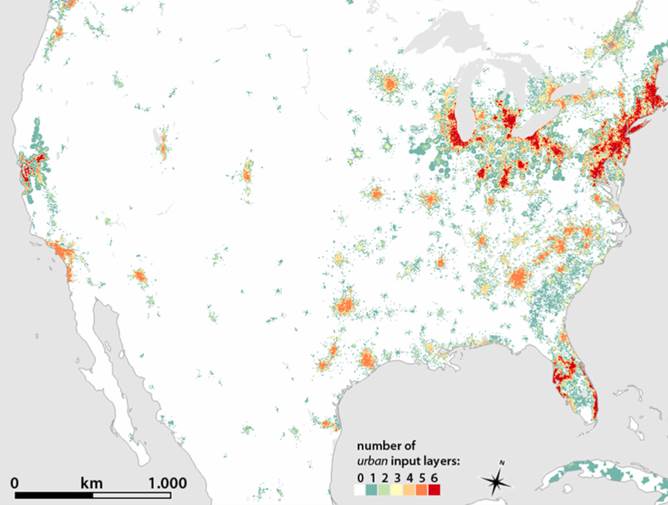
From the Abstract: Urban corridors are – from a spatial perspective – massively large, linear urban agglomerations consisting of a number of big cities or clusters aligned along high-speed road or rail lines. Fixed administrative boundaries are commonly used to define such urban areas. However, this does not usually reflect the actual extent of the built-up space in today’s changing, multi-faceted urban landscape. Earth observation data provide the means to identify urban space in its spatial dimension, disregarding preconceived boundaries. We therefore use multi-source geodata including night-time lights, settlement patterns and population density to spatially delineate large urban corridors in the United States and parts of Canada and Mexico. Using pre-classified input layers, we identify and present varying outlines of 14 urban corridors through geospatial methods. With this approach, we address spatial ambiguities of such concepts and show fuzziness at the edges of these corridors.
Read the full article here: https://www.sciencedirect.com/science/article/pii/S0264275122005686

