Exploring Wetland Ecosystems in the Rhön Biosphere Reserve

Exploring Wetland Ecosystems in the Rhön Biosphere Reserve

April 14, 2025

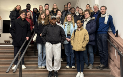
As part of our ongoing collaboration with our EOCap4Africa project partners, two members of the EORC (Dr. Insa Otte, Lilly Schell) at the University of Würzburg recently took a field trip to the Rhön Biosphere Reserve with our visiting scientists.

We visited two wetland sites—Rotes Moor and Schwarzes Moor—both important ecosystems that play a key role in regional biodiversity and climate regulation.


The excursion offered valuable on-the-ground insights into wetland ecology, restoration efforts, and the challenges of monitoring these dynamic landscapes. Observations in the field complemented our remote sensing approaches and sparked lively discussions on linking in-situ data with satellite-based analysis. Field experiences like this are essential for building shared understanding across disciplines and cultures—and for grounding our research in the real-world environments we aim to protect.

follow us and share it on:

you may also like:

EORC researchers teaching drone remote sensing at UNIS, Svalbard

EORC researchers teaching drone remote sensing at UNIS, Svalbard

During their current visit to Svalbard, EORC researchers have been teaching UNIS students from all over Europe on how drones can be used for remote sensing in the high Arctic. Invited by our UNIS collaborators Prof. Dr. Simone Lang (UNIS) and Prof. Dr. Eero Rinne...

Urban Earth Observation Lecture: Understanding Cities from Above

Urban Earth Observation Lecture: Understanding Cities from Above

As part of the EAGLE M.Sc. programme, our international students attended this winter term the Urban Earth Observation lecture by EORC professor Hannes Taubenböck. The session offered a comprehensive overview of how remote sensing has evolved into a central tool for...

Learning Geospatial Tools in Practice: whitebox

Learning Geospatial Tools in Practice: whitebox

A central goal of the EAGLE Earth Observation programme is to equip students with a broad and practical understanding of the software tools used in geospatial analysis. Rather than focusing on a single platform, students are encouraged to explore different approaches,...

Share This