On March 26, 2026, Georg Starz will present his Master Thesis on ” Synthetic High-Resolution Remote Sensing Image Generation – A Comparative Study of Model Training, Surface Data Variability and Evaluation Metrics” at 10:00 in seminar room 3, John-Skilton-Str. 4a.
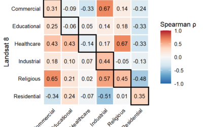
From the abstract: Deep Learning applications in the field of Earth Observation crucially depend on the availability of large and high-quality training datasets. Their creation is often difficult and time-consuming due to complex physical and semantic properties of Remote Sensing data. Synthetic data generation approaches enable creating additional high-quality and use case-specific training data, which has proven to enhance model performances in several Earth Observation applications. In this study, four Generative Adversarial Network (GAN) variants are trained on the German GeoNRW dataset to create high-resolution Remote Sensing RGB images based on surface model and land use / land cover (LULC) data. Carrying out an expert ranking of synthetic images, eight evaluation metrics from three categories are compared and LULC class-specific values are analyzed statistically using Spearman Rank Correlation. The results show that normalized digital surface model (nDSM) variants generate better synthetic imagery than digital surface model (DSM) GANs. EO Foundation Model Clay-derived metrics based on National Agriculture Imagery Program (NAIP) RGB data align best with expert ranking results and most strongly reflect the improvement in synthetic image quality throughout GAN training. The trend towards nDSM model variants and Foundation Model metrics predominantly persists for class-specific results. Overall, this study comprehensively addresses research gaps regarding GAN trainings in Remote Sensing, model and parameter choices, and objective and transferable synthetic image evaluation metrics. It paves the way for further use-case-specific synthetic data creation studies that will enable more efficient Deep Learning applications in Earth Observation.
1st supervisor: Prof. Dr. Tobias Ullmann
2nd supervisor: Dr. Thorsten Höser (DLR)
From the abstract: Deep Learning applications in the field of Earth Observation crucially depend on the availability of large and high-quality training datasets. Their creation is often difficult and time-consuming due to complex physical and semantic properties of Remote Sensing data. Synthetic data generation approaches enable creating additional high-quality and use case-specific training data, which has proven to enhance model performances in several Earth Observation applications. In this study, four Generative Adversarial Network (GAN) variants are trained on the German GeoNRW dataset to create high-resolution Remote Sensing RGB images based on surface model and land use / land cover (LULC) data. Carrying out an expert ranking of synthetic images, eight evaluation metrics from three categories are compared and LULC class-specific values are analyzed statistically using Spearman Rank Correlation. The results show that normalized digital surface model (nDSM) variants generate better synthetic imagery than digital surface model (DSM) GANs. EO Foundation Model Clay-derived metrics based on National Agriculture Imagery Program (NAIP) RGB data align best with expert ranking results and most strongly reflect the improvement in synthetic image quality throughout GAN training. The trend towards nDSM model variants and Foundation Model metrics predominantly persists for class-specific results. Overall, this study comprehensively addresses research gaps regarding GAN trainings in Remote Sensing, model and parameter choices, and objective and transferable synthetic image evaluation metrics. It paves the way for further use-case-specific synthetic data creation studies that will enable more efficient Deep Learning applications in Earth Observation.
1st supervisor: Prof. Dr. Tobias Ullmann
2nd supervisor: Dr. Thorsten Höser (DLR)