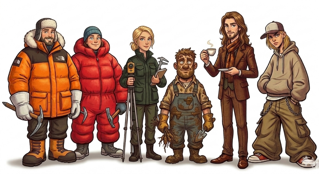
A fun field guide of earth observation scientists at our EORC, a typology of 6 Species of Remote Sensing Researchers (we could not think of more yet …)
There’s a magical moment in every remote sensing get-together when six completely different personalities somehow end up at the same time in the same kitchen, Polar Bear or Penguin aisle and talking about their past, present or future research – and sometimes, like today such discussions end up in fun jokes about each other – that was the moment when Ariane and Martin came of with the types of Earth Observation scientist. A little bit true but more important funny differentiation of our EORC researchers.
These different types have stories about standing on the castle to observe the city, for science of course or standing knee-deep in Arctic snow trying to rescue a GNSS antenna from a snowstorm. Or struggling to adjust a PowerPoint color palette called “Earthy Sustainability Beige.” Sometimes it is even the same person. And somehow… this is part of our day-to-day science.
Welcome to the ecosystem of remote sensing research. And our fun, subjective, humorous differentiation of our differnt EO scientist types at EORC:
Remote sensing is often described as “The science of observing Earth from a distance.” Which sounds elegant and futuristic until you realize the actual workflow involves frozen batteries, corrupted GeoTIFFs, mysterious CRS errors, and somebody yelling: “WHO REPROJECTED THIS IN EPSG:4326?!” Welcome to remote sensing research where satellites, drones, field mud, and existential debugging somehow become a scientific discipline. And that is where our types come into the game.
1. The GNSS Guru
“The signal is better over there.”
The GNSS Guru does not believe in roads, comfort, or weather forecasts.
Their natural habitat includes:
-
glaciers
-
forests
-
mountain ridges
-
locations marked “probably accessible” on old maps
They can locate survey points with terrifying precision:
“We’re only 12 centimeters off.”
Meanwhile everyone else is still trying to figure out where “north” is.
Favorite hobbies:
-
arguing about RTK corrections
-
waiting for satellite lock
-
Will absolutely hike 6 hours to validate one pixel.
Because:
“Ground truth matters.”
Equipment carried:
-
3 power banks
-
2 thermos flasks
-
14 layers of existential resilience
Their biggest fear? Cloud cover and low battery warnings.
2. The Mud Magician
“That’s premium soil.”
Nobody understands soil, agriculture or everything else related to the ground better than these scientists.
The Mud Magician can identify:
-
sediment layers
-
agricultural conditions
-
soil moisture
-
or emotional support mud
The Mud Magician believes no remote sensing model is complete without:
-
47 soil samples
-
suspiciously heavy backpacks
-
and boots that violate international cleanliness standards
They collect:
-
soil moisture
-
vegetation samples
-
LAI measurements
-
emotional trauma from field campaigns
They collect samples like Pokémon cards and become personally offended when someone calls soil “just dirt.”
Every field trip ends with:
-
wet socks
-
broken equipment
-
and a folder called:
“final_FINAL_v2_real.nc”
Their car interior contains enough sediment layers to qualify as stratigraphy.
3. The Drone Whisperer
“One more flight.”
The Drone Whisperer treats drones like emotional companions.
They speak softly to batteries.
They trust wind forecasts from obscure apps nobody else has heard of.
Has flown drones in:
-
snowstorms in the Alps
-
mosquito swarms in Africa
-
Arctic wind on Svalbard
-
conditions officially labeled “absolutely not”
Storage situation:
- 18 set of UAS batteries
-
14 TB of hard drive
-
0 bytes free
Favorite phrase:
“I think the propeller sounds weird.”
Will absolutely risk climbing a tree to rescue a drone worth more than their car.
4. The KPI Influencer
“We need scalable geospatial narratives.”
The KPI Influencer has not touched actual soil in years.
But they have:
-
optimized workflows
-
aligned stakeholders
-
leveraged synergies
-
updated LinkedIn twice today
Their fieldwork mainly consists of:
-
city trips
- urban sight-seeing spots like our famous castle in Würzburg (just perfect to see the morphology of the city)
-
conferences in weird unknown cities (because the conference is just an excuse to research a new city)
-
cafés with acceptable coffee beans
Possesses five Patagonia vests and exactly one pair of suspiciously clean hiking boots.
Can turn a single satellite image into:
-
82 presentation slides
-
4 dashboards
-
1 TED-Talk-looking keynote
- into an award-(or science-slam)-winning presentation
5. The Street-Cred Sommelier
“Science, but aesthetic.”
This researcher believes data visualization should feel emotionally curated.
Their workstation contains:
-
a perfectly structured workflow for urban data analysis
-
minimalist notebooks
-
ethically sourced coffee
-
at least one indoor plant named after a satellite mission
Believes every land-cover classification deserves:
-
cinematic lighting, adequate to see the urban structure
-
a shaded relief in the background with a semi-translucent, blending mode multiply setting in QGIS
-
and a moody bluesky post
Posts captions like:
“Urban Data is the new soil 🌍✨”
Has never removed a tick.
Has definitely designed a conference slide deck with custom typography.
Can detect bad color palettes faster than land cover change.
6. The Code Craftswoman
“It worked yesterday.”
Lives somewhere between:
-
Python scripts, R code, GeoJulia commands
-
emotional instability depends on code stability
-
and Stack Overflow tabs (or nowadays AI chats)
She transforms chaotic raw data into:
-
maps
-
models
-
figures
-
miracles
Nobody fully understands what she’s doing, including herself after 2 AM.
Can process:
-
Sentinel imagery
-
LiDAR point clouds
-
SAR backscatter
-
hyperspectral cubes
-
emotional damage
Nobody truly understands her workflow.
Her desktop contains:
-
400 scripts
-
17 virtual environments
- 5 paper outlines
- 3 new project proposals
-
one notebook called: “THIS_ONE_WORKS.ipynb”
Current mental state:
try: survive() except: coffee += 1 Can fix an entire workflow in five minutes…
or accidentally delete three weeks of preprocessing.
Still somehow saves the project every single time.
The Truth Nobody Admits
Remote sensing, our EORC, only works because all these personalities do exist, do work together, do like each other – and therefore are also able to make fun of each other.
The field teams bring:
-
reality into data patterns
-
measurements for great research
-
but also frozen fingers and muddy boots
The urban teams bring:
-
urban reasoning
- fancy mobility and urban morphology analysis
-
polished figures
-
dashboards
-
words like “stakeholder alignment”
Together they turn:
satellite pixels → scientific insight → grant proposals → great articles (or conference posters nobody reads completely).
And somewhere in the distance:
a drone crashes softly into a spruce tree while someone quietly whispers:
“Telemetry lost.” (that only happened once years ago, before the UAS team actually existed and we flew like in the wild west)
Final Thoughts
Remote sensing is not just a scientific discipline. It’s a chaotic alliance between:
-
satellites
-
field boots
-
Python/R/GeoJulia/Java scripts
-
drone batteries
-
geospatial buzzwords
-
and caffeine dependency
and of course people, humans, with their own characters, approaches, skills, ideas, ….
And their science with different habitats, different environments, maybe even different workflows but same methods, same data.
Sometimes trouble and annoyance and stress, but same mission:
Understanding Earth one Sentinel raster at a time.
of course: all similarity to existing people, colleagues are totally random and we are very thankful for our AI interfaces for following our prompts as much as possible for creating the figures.