new publication: Measuring rural settlement expansion in Uzbekistan using remote sensing to support spatial planning

new publication: Measuring rural settlement expansion in Uzbekistan using remote sensing to support spatial planning

April 29, 2015

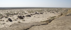
Aral Sea / ship graveyard in Muinak, Uzbekistan

Photo by C. Conrad

In this publication we focused on methods to measure the outcome of population growth in rural Uzbekistan. Bi-temporal change detection based on 2.5m SPOT data gave insights into the competition for valuable land resources.


Conrad, C., Rudloff, M., Abdullaev, I., Thiel, M., Löw, F., Lamers, J.P.A., Measuring rural settlement expansion in Uzbekistan using remote sensing to support spatial planning, Applied Geography, Volume 62, August 2015, Pages 29–43. http://www.sciencedirect.com/science/article/pii/S0143622815000831

you may also like:

Exploring Wetland Ecosystems in the Rhön Biosphere Reserve

Exploring Wetland Ecosystems in the Rhön Biosphere Reserve

As part of our ongoing collaboration with our EOCap4Africa project partners, two members of the EORC (Dr. Insa Otte, Lilly Schell) at the University of Würzburg recently took a field trip to the Rhön Biosphere Reserve with our visiting scientists. We visited two...

Studies on global urbanization

Studies on global urbanization

Urbanization is one of the major drivers of global change. Statistically every single week an estimated 1.5 million people are added to cities worldwide. Over the last 15 years, our team at the Earth Observation Center (EOC) of the German Aerospace Center (DLR) and...