In an era of climate uncertainty and increasing pressure on agricultural systems, understanding how crops grow and respond to environmental stress is more important than ever. A new study led by researchers from Martin-Luther-University Halle-Wittenberg, in close collaboration with the Data Cube team at the EORC (University of Würzburg), introduces a new framework that uses radar satellite data to monitor crop development—without relying heavily on field observations.
Sentinel-1: A Radar Eye in the Sky
The European Space Agency’s Sentinel-1 satellites offer a unique advantage: they can “see” through clouds and capture data every six days across Europe. This makes them ideal for tracking crop growth, especially in regions with frequent cloud cover.
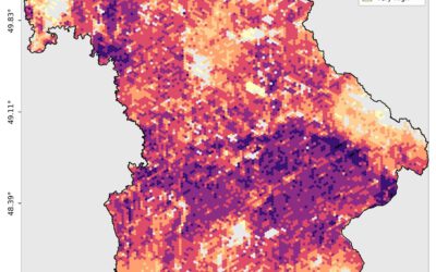
Unlike traditional methods that depend on optical imagery or labor-intensive field campaigns, this study leverages Synthetic Aperture Radar (SAR) time series to detect key changes in crop development. The researchers focused on three major crops—winter wheat, canola, and sugar beet—at the DEMMIN test site in northeastern Germany.
From Landscape to Field: A Multi-Scale Approach
What sets this study apart is its integration of landscape-scale patterns with field-level phenology. Using radar-derived time series metrics (TSMs) and a temperature-based model called Growing Degree Days (GDD), the team was able to identify when and where crops undergo key developmental stages.
Why It Matters
This framework offers a scalable, transferable method for crop monitoring that can support:
- Precision agriculture
- Yield forecasting
- Climate resilience assessments
- Policy-making and disaster response
By reducing dependence on ground-based observations, it opens the door to real-time, large-scale agricultural monitoring—a crucial step toward smarter farming in a changing climate.
A Collaborative Effort
This innovative approach is the result of a new development by the research team at Martin-Luther-University Halle-Wittenberg, carried out in close cooperation with the Data Cube team at the University of Würzburg. The integration of advanced SAR analytics with scalable data infrastructure highlights the power of interdisciplinary collaboration in tackling real-world agricultural challenges.
What’s Next?
The authors suggest that future research could expand this approach to national scales, other crop types, or even forest and snow phenology. With cloud computing and AI-driven analytics, near real-time crop performance tracking may soon become a reality.
Read the full study: Frontiers in Remote Sensing