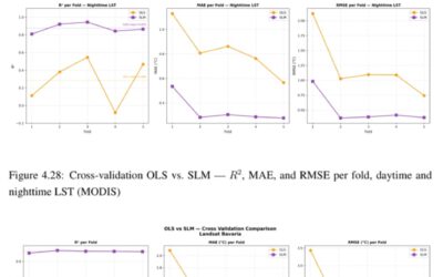
On 3-6 September 2023 the SPIE Remote Sensing conference took place in Amsterdam. Lorenza Gilardi, working at German Remote Sensing Data Center (DFD) of the German Aerospace Center (DLR) and carrying out her PhD at the JMU ( https://remote-sensing.org/new-phd-candidate-lorenza-gilardi/ ), contributed to the session Remote Sensing Technologies and Applications in Urban Environments with her presentation “Regional mobility patterns and exposure to environmental stressors: effects on the health risk assessments due to air pollution“.
Here is the abstract: Urban environments are often characterized by high levels of air pollution, representing a significant risk to human health. This study presents a methodology for conducting a retrospective and indirect health risk assessment in urban areas, due to the long-term exposure to particulate matter (PM2.5), nitrogen dioxide (NO2), ozone (O3). Specifically, the risk of all-causes mortality is investigated. For this purpose, relative risk values from the World Health Organization were used. The methodology combines various data sources that are available over a large geographical scale. They include: satellite-based settlement data, model-based air pollution data, land use information, demographic data, and regional-scale mobility patterns. By incorporating these factors, the study examines the impact of population mobility on the population exposure and daily variations in pollutant levels on health risks. As a results two health metrics are derived: The Health Risk Increase (HRI) and the Health Burden (HB). The results from the study show that neglecting the mobility patterns and the diurnal cycles of pollutants can lead to an underestimation of the health risk. This methodology tries to fill the data gap encountered when information on personal exposure are needed at population level. The incorporation of satellite and model data makes it scalable and easy tunable to perform a health risk assessment also in remote regions, where local sensors are limited, for example by using globally available pollution datasets. This methodology can be extended to cover the additional environmental stressors, like heat/cold stress, and health endpoints. and Additional studies are required to assess the uncertainty in the exposure when using these medium to- low resolution data.
Here is the link to the contribution and the presentation: https://www.spiedigitallibrary.org/conference-proceedings-of-spie/12735/3000174/Regional-mobility-patterns-and-exposure-to-environmental-stressors–effects/10.1117/12.3000174.full?SSO=1