
On June 09, 2026, Anna Bischof will present her Master Thesis on ” Feasibility of Unoccupied Aerial System-Based Active Fire Monitoring in African Savannas” at 12:00 in seminar room 3, John-Skilton-Str. 4a.
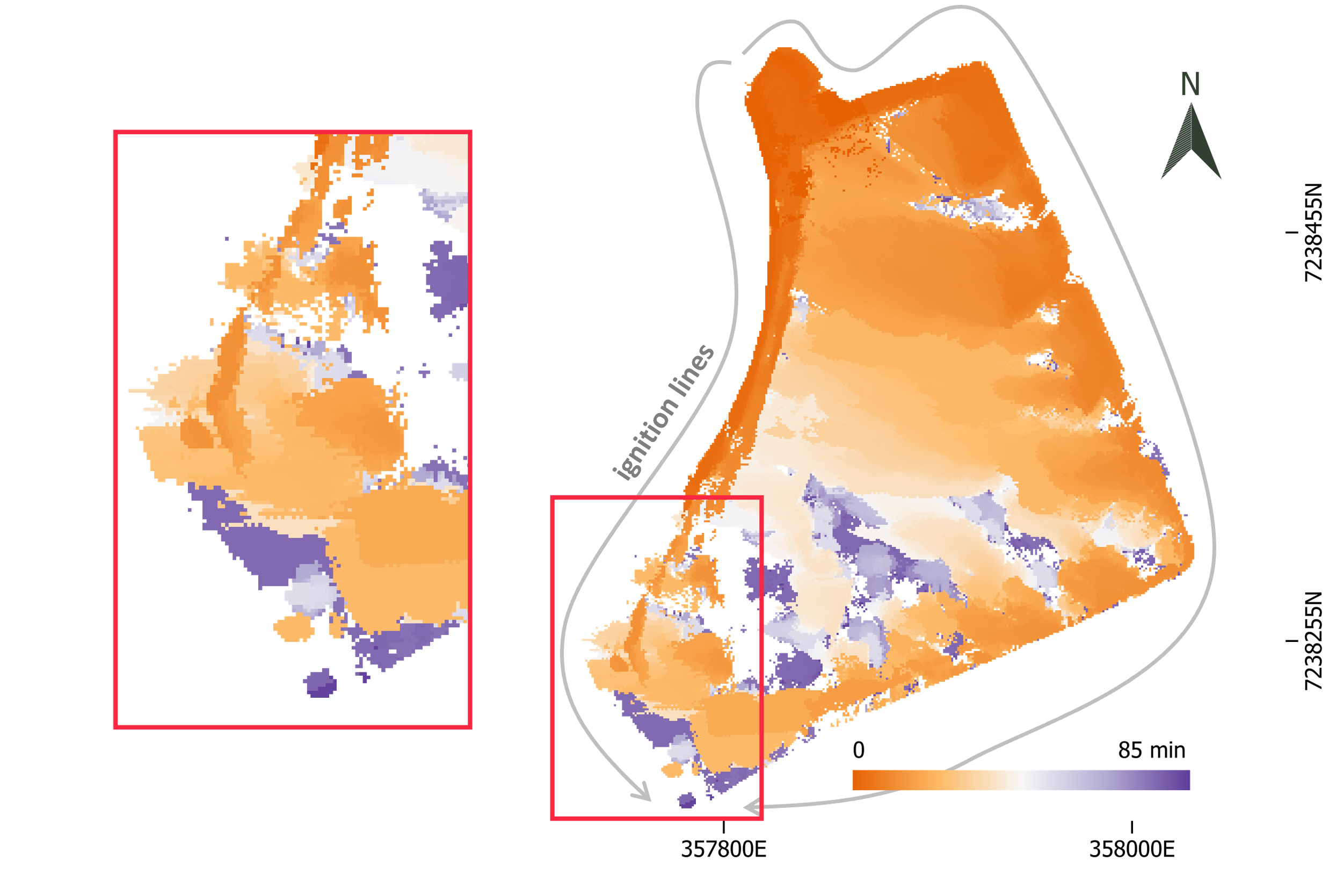
From the abstract: Fire is a fundamental Earth system process that links biogeochemical cycles and shapes ecosystem structure globally. In savannas, recurring fire maintains the coexistence of trees and grass, making fire dynamics central to ecosystem functioning. Satellite-based active fire monitoring is widely used to characterize fire occurrence, but its spatial and temporal resolution is insufficient to capture fine-scale fire behavior such as flame-front propagation and rate of spread, which impact vegetation. UAS provide observations at ecologically relevant scales, but their application for active fire monitoring in savannas remains limited. This thesis evaluates the feasibility of UAS-based active fire monitoring in savanna ecosystems, focusing on how observation geometry and temporal sampling influence the representation of fire dynamics. Data were collected during a prescribed burn in Kruger National Park, South Africa, on 11 August 2025 using a coordinated three-platform UAS deployment. Over 10,000 thermal images were acquired during an 87-minute period across a 6-hectare study area. An acquisition-aware orthorectification framework was developed to transform oblique thermal imagery into georeferenced products without ground control points. The resulting thermal time series was used to compare acquisition strategies and derive a spatially explicit time-to-burn map. Oblique and nadir acquisition strategies captured complementary aspects of fire dynamics. Oblique imagery provided broad spatial coverage and near-continuous temporal observations, while nadir imagery delivered higher spatial detail over smaller areas. The time-to-burn map reconstructed fire progression and identified multiple advancing fire fronts and distinct phases of fire development. The study demonstrates that UAS-based active fire monitoring in savanna ecosystems is feasible and that multi-platform approaches can balance spatial coverage, detail, and temporal continuity in heterogeneous fire environments.
1st supervisor: Antonio José Castañeda-Gómez
2nd (external) supervisor: Dr. Mirjana Bevanda
From the abstract: Fire is a fundamental Earth system process that links biogeochemical cycles and shapes ecosystem structure globally. In savannas, recurring fire maintains the coexistence of trees and grass, making fire dynamics central to ecosystem functioning. Satellite-based active fire monitoring is widely used to characterize fire occurrence, but its spatial and temporal resolution is insufficient to capture fine-scale fire behavior such as flame-front propagation and rate of spread, which impact vegetation. UAS provide observations at ecologically relevant scales, but their application for active fire monitoring in savannas remains limited. This thesis evaluates the feasibility of UAS-based active fire monitoring in savanna ecosystems, focusing on how observation geometry and temporal sampling influence the representation of fire dynamics. Data were collected during a prescribed burn in Kruger National Park, South Africa, on 11 August 2025 using a coordinated three-platform UAS deployment. Over 10,000 thermal images were acquired during an 87-minute period across a 6-hectare study area. An acquisition-aware orthorectification framework was developed to transform oblique thermal imagery into georeferenced products without ground control points. The resulting thermal time series was used to compare acquisition strategies and derive a spatially explicit time-to-burn map. Oblique and nadir acquisition strategies captured complementary aspects of fire dynamics. Oblique imagery provided broad spatial coverage and near-continuous temporal observations, while nadir imagery delivered higher spatial detail over smaller areas. The time-to-burn map reconstructed fire progression and identified multiple advancing fire fronts and distinct phases of fire development. The study demonstrates that UAS-based active fire monitoring in savanna ecosystems is feasible and that multi-platform approaches can balance spatial coverage, detail, and temporal continuity in heterogeneous fire environments.
1st supervisor: Antonio José Castañeda-Gómez
2nd (external) supervisor: Dr. Mirjana Bevanda