


follow us and share it on:
you may also like:

Small Gesture, Big Thanks: Chocolate in the Polar Bear Kitchen
Pulling off a party for 250 people doesn't happen by magic. It happens because a bunch of people quietly say yes to the boring jobs, the carrying, the setting up, the standing around answering questions, the cleaning up afterward. Our combined 25th anniversary for...

From the lecture hall into the forest
A recent visit to the University Forest Sailershausen brought students together with Forest Management to discuss current challenges in forestry under a changing climate. Hosted by the head of the forest administration Daniel Kraus, the day combined presentations by...

Can We Teach Everything Except the Most Important Thing?
Over the past years, we have had many discussions within our research group and with colleagues at other universities about the changing culture in academia. These conversations often revolve around funding, publication pressure, career perspectives, or the increasing...

Linking Science and Practice: Exploring Earth Observation for Water Management
How can Earth observation support sustainable water management in times of climate change? This question was at the center of a recent visit by participants of the EAGLE block course "Linking Science and Practice in Earth Observation for Climate Adaptation" to the...

“MainPro” working meeting on municipalities dealing with flooding and heavy rainfall
How do the municipalities in the Lower Franconian Main valley deal with flooding and heavy rainfall? This question was the focus of a working meeting of the Remote Sensing and Social Geography working groups on July 15, 2026, for the "MainPro" research project...
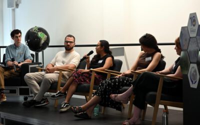
Four Paths, One EAGLE: An Alumni Plenary Worth Talking About
We got to sit in on something really special during our 10 year of EAGLE anniversary: a plenary discussion with four EAGLE alumni, moderated by Will, one of our 10th generation students. And honestly, it was one of those sessions where you look around the room and...