new article on African protected areas

new article on African protected areas

October 10, 2014

Wegmann et al_Phil_Trans_PA_irreplaceabilityOur new article about the “Role of African protected areas in maintaining connectivity for large mammals” has been published in a special issue on Remote Sensing in Biodiversity and Conservation.

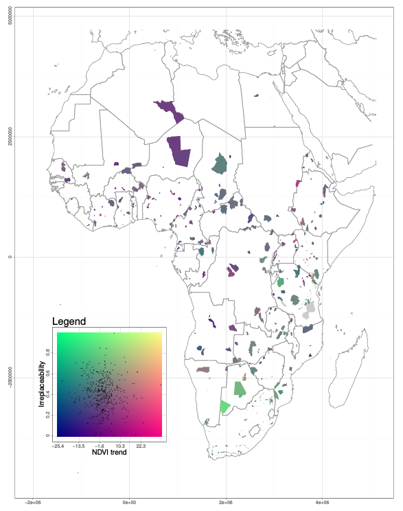
The African protected area (PA) network has the potential to act as a set of functionally interconnected patches that conserve meta-populations of mammal species, but individual PAs are vulnerable to habitat change which may disrupt connectivity and increase extinction risk. Individual PAs have different roles in maintaining connectivity, depending on their size and location. We measured their contribution to network connectivity (irreplaceability) for carnivores and ungulates and combined it with a measure of vulnerability based on a 30-year trend in remotely sensed vegetation cover (Normalized Difference Vegetation Index). Highly irreplaceable PAs occurred mainly in southern and eastern Africa. Vegetation cover change was generally faster outside than inside PAs and particularly so in southern Africa. The extent of change increased with the distance from PAs. About 5% of highly irreplaceable PAs experienced a faster vegetation cover loss than their surroundings, thus requiring particular conservation attention. Our analysis identified PAs at risk whose isolation would disrupt the connectivity of the PA network for large mammals. This is an example of how ecological spatial modelling can be combined with large-scale remote sensing data to investigate how land cover change may affect ecological processes and species conservation.


Theme Issue ‘Satellite remote sensing for biodiversity research and conservation applications’ compiled and edited by Nathalie Pettorelli, Kamran Safi, Woody Turner and Stefan Dech

follow us and share it on:

you may also like:

Course on urban EO by Michael Wurm

Course on urban EO by Michael Wurm

Walk through any city and you pick up on things that are hard to put a number on. The noise of a main road, the heat that sits between buildings in summer, the question of whether that little park around the corner is really enough green space for the whole...

EireR R package: unified gateway to Irish geospatial data

EireR R package: unified gateway to Irish geospatial data

Anyone who's tried to do geospatial work across the whole island of Ireland knows the headache. Ireland is one island geographically, but it's split across two jurisdictions, the Republic and Northern Ireland, and each one runs its own data infrastructure. Different...

Impact of agrophotovoltaic facilities – an R package

Impact of agrophotovoltaic facilities – an R package

There's a new R package on the block, and it's solving a problem that sounds simple until you actually try to do it: how do you tell whether putting solar panels over a farm field is good or bad for the soil and the crops around them? Marlene, one of our EAGLE...

New paper on GDP estimatation from space

New paper on GDP estimatation from space

Reliable and up-to-date sub-national data on the gross domestic product (GDP) data remain scarce in many regions across the globe. However, in a new study we show how high-resolution GDP estimates can be derived from multisource remote sensing and auxiliary inputs...

Presentation at the Kolloquium of the Technical University of Graz

Presentation at the Kolloquium of the Technical University of Graz

Dr. Ariane Droin presented the works of her PhD-Thesis at the Geo-Kolloquium of the Technical University of Graz with the title "Hochauflösende, skalenübergreifende Modellierung von Nachbarschaftserreichbarkeiten im urbanen Raum" on the 17th of June 2026. She showed...

Share This