New GeoSens Trainings at the Department of Remote Sensing – Registration is open

New GeoSens Trainings at the Department of Remote Sensing – Registration is open

June 27, 2022

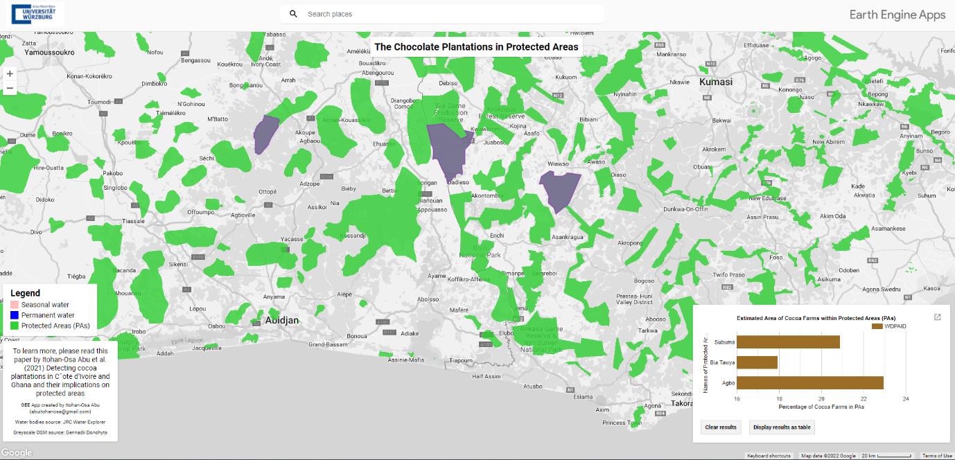
Would you like to learn more about integrating Earth observation data and especially remote sensing data in international collaboration and working with open-source tools such as QGIS and Google Earth Engine, in addition to exchanging ideas in an international atmosphere? Then the GeoSens trainings might be the right thing for you.

The GeoSens pieces of training will take place in person* and aim at project members of various organizations such as WWF, GIZ, KfW, and others.

There are three different training sessions to choose from “Integrating Remote Sensing in International Development Work” (EO4IntDev), “Introduction to Remote Sensing with QGIS” (EO4QGIS), and “Introduction to Remote Sensing with Google Earth Engine” (EO4GEE). More information such as the addressees of the trainings, times, possibilities for registration, etc. can be found at http://geosens.org

*Depending on the covid 19 pandemic situation and regulations, we would, if necessary, substitute the possibility of online training. In this case, the training will be provided online via the platforms MS Teams/Zoom.

Example of a remote sensing project for the chocolate plantations in protected areas in Côte d’Ivoire and Ghana (West Africa) that was entirely created in Google Earth Engine. © Itohan-Osa Abu et al. (2021), https://doi.org/10.1016/j.ecolind.2021.107863

follow us and share it on:

you may also like:

New Funded Project on Automated Detection of Mining Areas

New Funded Project on Automated Detection of Mining Areas

In a newly launched research project funded by the KSB Foundation, we focus on the automated identification of mining areas based on remote sensing data. The aim is to systematically detect large-scale mining activities and to track their spatial and temporal...

New Earth Observation Project on Thermal Satellite Data

New Earth Observation Project on Thermal Satellite Data

We are honored that we are part of a new research and development project, focusing on the development of a satellite constellation capable of delivering high-resolution thermal data with a high revisit rate. The observations aim to make an important contribution to...

Super-Test-Site Würzburg meeting

Super-Test-Site Würzburg meeting

The team of our "Super-Test-Site Würzburg" consortium (University of Würzburg, the Karlsruhe Institute of Technology, the Friedrich-Alexander-University Erlangen-Nürnberg, Leibniz-Institute for Länderkunde in Leipzig  and the German Aerospace Center)...

MainPro Project Meeting: Next Project Phase Launched

MainPro Project Meeting: Next Project Phase Launched

On Friday, November 21st, a MainPro project meeting was held to exchange ideas with our cooperating small and medium-sized enterprises (SMEs). Within our MainPro project, we aim to identify the changes caused by climate change in the Main Valley and its surroundings...

Share This