New publication: Forest inventories by LiDAR data: A comparison of single tree segmentation and metric-based methods for inventories of a heterogeneous temperate forest

New publication: Forest inventories by LiDAR data: A comparison of single tree segmentation and metric-based methods for inventories of a heterogeneous temperate forest

m

July 16, 2015

A new paper led by the Dept. of Remote Sensing presents an in-depth insight into practical implementations of a fullwave LiDAR survey for deriving essential forest structural variables on landscape scale. Carried out in the entire territory of Bavarian Forest National Park in Germany, this work evaluated two fundamentally-different methods of forest inventory that use LiDAR data at the landscape level: the single tree segment-based method and an area-based method. A set of structural forest attributes were modeled by these methods with a conventional forest inventory of the highly heterogeneous forest landscape which partially includes stands affected by severe natural disturbances.

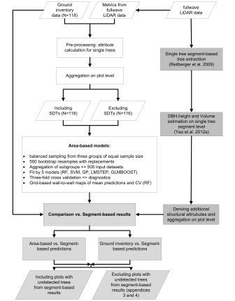
Methodology adopted to the study

The single tree-based algorithm delivered highly reliable estimates of variables and their uncertainty for a set of forest structural attributes that are of interest in forest inventories at the landscape scale. This was also well correlated with the results obtained form traditional metric-based LiDAR models as well as with those form field-based forest inventory. Based on the obtained results, this work recommends LiDAR forest inventories at the landscape scale in both heterogeneous commercial forests and large protected areas in the central European temperate sites.

Latifi, H., Fassnacht, F.E., Müller, J., Tharani, A., Dech, S., Heurich, M. 2015. Forest inventories by LiDAR data: A comparison of single tree segmentation and metric-based methods for inventories of a heterogenuous temperate forest. Int. J. Appl. Earth Obs. Geoinf. doi:10.1016/j.jag.2015.06.008


you may also like:

EORC at the International Africa Festival 2025 in Würzburg

EORC at the International Africa Festival 2025 in Würzburg

If you know Würzburg, you certainly know the International Africa Festival, Europe's largest and oldest festival for African music and culture. For 15 years in a row now, the university tent has been an integral part of the festival. This is where the...

EO4CAM meeting at LfU in Augburg on grassland in Bavaria

EO4CAM meeting at LfU in Augburg on grassland in Bavaria

As part of the EO4CAM project (Earth Observation Laboratory for Climate Adaption and Mitigation), representatives of the Bavarian Environment Agency (LfU), the German Aerospace Centre (DLR), and the Earth Observation Research Cluster (EORC) met at the LfU in...

New R Package Enhances UAS Research and Planning

New R Package Enhances UAS Research and Planning

We’re excited to share the development of a new R package created by our PhD student, Antonio Castaneda Gomez, whose contributions to Uncrewed Aerial Systems (UAS) research continue to impress. Known as the brain behind many of our UAS data collection...

Radio Bavaria BR2 covered our activities at the Africa-Festival

Radio Bavaria BR2 covered our activities at the Africa-Festival

Once again, our team proudly took part in the International Africa Festival in Würzburg, continuing our active participation within the University of Würzburg's exhibition—a tradition we’ve upheld for many years. This year’s event highlighted the ongoing commitment of...

Mapping Paleontology using UAS on cliffs

Mapping Paleontology using UAS on cliffs

We’ve recently started an exciting research project focused on mapping steep rock slopes that contain valuable paleontological information. Unlike most drone surveys that focus on horizontal ground surfaces, our work is aimed vertically—capturing data along exposed...