New Publication by EORC and colleagues from the Department of Geoecology, Martin Luther University Halle-Wittenberg, German Aerospace Center, German University of Technology GUtech, Sultanate of Oman and the Leibniz Centre for Agricultural Landscape Research.
Link to the article: https://www.degruyterbrill.com/document/doi/10.1515/geo-2025-0953/html
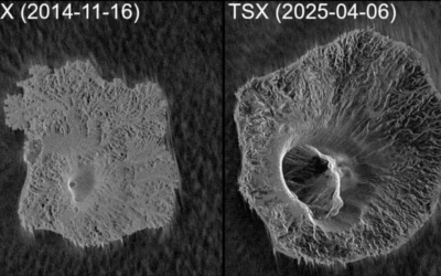
Abstract: In April 2024, northern Oman experienced an extreme flash flood triggered by rainfall totals exceeding one to two years of the regional average within 24 h. This study evaluates the performance of three remote sensing approaches for mapping flood-activated channels: Sentinel-2 Tasseled Cap Transformation (TCT) Brightness, Sentinel-1 Amplitude Change Detection (ACD), and Sentinel-1 InSAR Coherent Change Detection (CCD). Multi-temporal optical, SAR amplitude, and SAR coherence datasets were processed and compared with hydrological terrain indices derived from TanDEM-X elevation data. Results show that CCD provided the clearest and most spatially consistent delineation of flood channels, unaffected by cloud cover and less prone to noise than ACD, while integrating changes over time into a single product. Inside flow channels, coherence difference was shown to drop by up to 0.6 and being considerably lower than during stable conditions. TCT effectively highlighted bleaching of alluvial deposits under clear-sky conditions, and ACD proved most useful where flooding persisted at the time of acquisition. The combined analysis demonstrates that CCD, supported by optical and terrain data, offers a robust and transferable method for post-event flood mapping in arid regions. Its compatibility with Sentinel-1’s acquisition strategies makes it a practical tool for preliminary flood mapping and post-event assessment, especially in the context of increasingly frequent extreme rainfall events.