New publication on identifying and analysing intra-urban (sub-)centre structures comparing official 3D-building models and TanDEM-X nDSMs
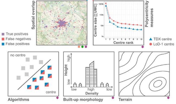
Researchers from the Earth Observation Center (EOC) of the German Aerospace Center (DLR) in Oberpfaffenhofen, the Research Institute for Regional and Urban Development (ILS) in Dortmund, the Company for Remote Sensing and Environmental Research (SLU) in Munich, and the University of Würzburg in Würzburg teamed up for a study on identifying and analysing intra-urban (sub-)centre structures comparing official 3D-building models and TanDEM-X nDSMs. The paper titled “In the tension between large-scale analysis and accuracy – Identifying and analysing intra-urban (sub-)centre structures comparing official 3D-building models and TanDEM-X nDSMs” was just published in the Journal Computers, Environment & Urban Systems by Ines Standfuß, Christian Geiß, Marlene Kühnl, Ariane Droin, Johannes Mast, Michael Wurm, Stefan Siedentop, Bastian Heider & Hannes Taubenböck. They investigated whether globally available and consistent TanDEM-X nDSMs (TDX) provide a valid data base for intra-urban polycentricity research based on built-up volumes. They found high spatial resemblances between the mapped (sub-)centres in TDX and LoD-1 data. The results of this study suggest that TDX nDSMs reflect the distribution of built-up structures in sufficient detail so that local-spatial densifications – here equated with (sub-)centres – can be appropriately studied.
From the Abstract: Intra-urban polycentricity has often been described by a balanced distribution of jobs/residences outside the traditional core cities in so-called (sub-)centres. Recently, this purely socioeconomic view has changed, so that centres are also increasingly understood as a physical manifestation of spatial development policies. Built-up volumes derived from 3D-building models are therefore frequently used instead of or as complement to employment/population figures when studying intra-urban polycentricity. However, such data are expensive and not available universally and permit only geographically limited investigations to date. To overcome this constraint, we investigate whether globally available and consistent TanDEM-X nDSMs (TDX) provide a valid data base for intra-urban polycentricity research based on built-up volumes. Our study focuses on four urban regions in Germany for which we have obtained official 3D-building models (LoD-1). For each study site, we derive aggregated built-up volumes from the TDX and the LoD-1 data and identify (sub-)centres. We use three centre identification algorithms to account for the diversity of methods and outcomes. We consider the LoD-1 (sub-)centres as reference and the TDX (sub-)centres as the entities to be reviewed. First, we quantify their spatial agreement and compare if polycentricity measures calculated based on both data sets lead to similar results. Second, we explore possible causes for discrepancies between the TDX/LoD-1 (sub-)centres. We find high spatial resemblances between TDX and LoD-1 (sub-)centres. Accordingly, we observe that polycentricity measures display similar trends among the two data sets. Nevertheless, we also show that the agreement between TDX and LoD-1 centres can be affected in uneven terrain, in sparsely built-up areas, and by the algorithms used to identify (sub-)centres. Overall, our results suggest that TDX nDSMs reflect the distribution of built-up structures in sufficient detail so that local-spatial densifications – here equated with (sub-)centres – can be appropriately studied. We therefore conclude that TDX data offer a great potential for the thematic domain of morphological urban analysis at large scale.
Read the full article here: https://www.sciencedirect.com/science/article/pii/S0198971523000169
This paper is related to a series of studies in the domain pf polycentricity research. Please see related papers here:
https://www.tandfonline.com/doi/full/10.1080/07352166.2022.2122833
https://www.sciencedirect.com/science/article/pii/S0198971517300479
https://ieeexplore.ieee.org/document/8745682
https://www.mdpi.com/2220-9964/5/6/76

