New publication: Remote sensing solutions for monitoring species diversity as affected by invasive plants

New publication: Remote sensing solutions for monitoring species diversity as affected by invasive plants

February 6, 2017

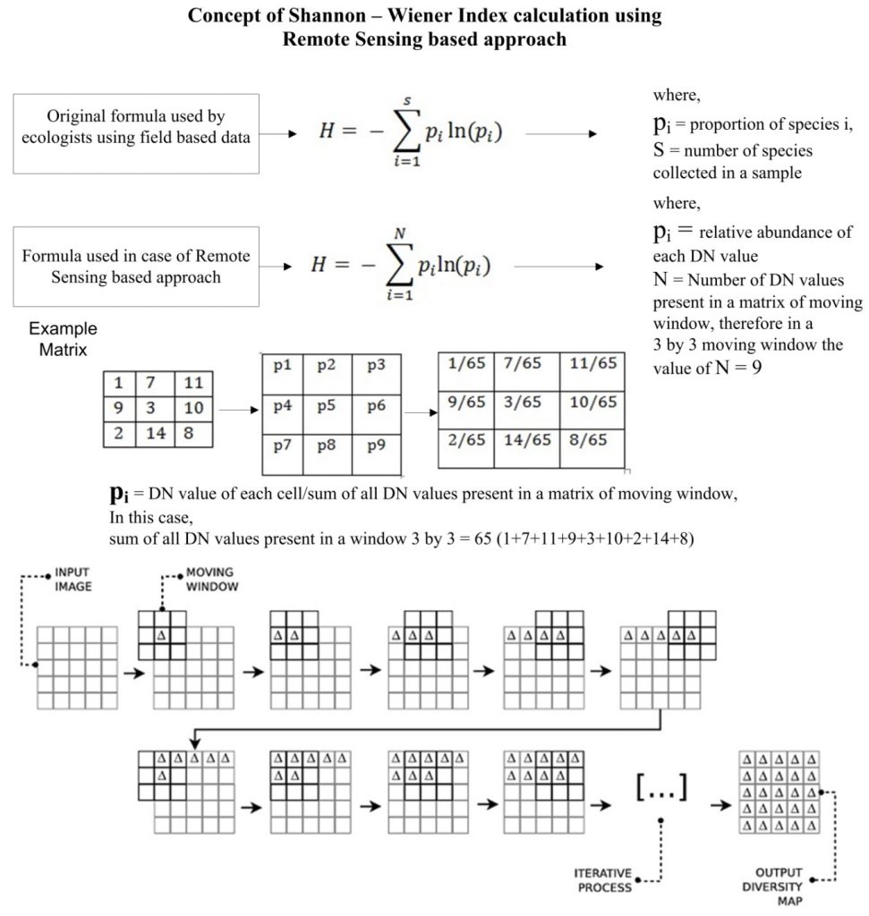
A new published work featuring Hooman Latifi from Dept. of Remote Sensing and Siddhartha Khare from Indian Institute of Technology Roorkee presents a full remote sensing-based approach to assess the vegetation diversity across the areas affected and invaded by Lantana camara, an invasive plant species. The study comprises two main steps  utilizing  multi-source satellite earth observation data. The process starts with a supervised classification applied on ery high spatial resolution Pléiades 1A data, and continues with comparing Pléiades 1A, RapidEye and Landsat-8 OLI – assessed plant species diversities.

Schematic representation of plant diversity estimaiton by remote sensing approach

With detailed mathematical formulation combined with an straightforward methodology solely based on optical remote sensing data, the study is expected to add a new baseline to the existing studies on solutions for remote and rapid estimation of biodiversity attributes in mountaineuous forest areas. Further informaiton on the published paper can be retrieved here.

Bibliography:

Khare, S., Latifi, H., Ghosh, S.K., 2017. Multi-scale assessment of invasive plant species diversity using Pléiades 1A, RapidEye and Landsat-8 data. Geocarto International . DOI: 10.1080/10106049.2017.1289562


you may also like:

Bridging Scales: How Radar Satellites supports Crop Monitoring

Bridging Scales: How Radar Satellites supports Crop Monitoring

In an era of climate uncertainty and increasing pressure on agricultural systems, understanding how crops grow and respond to environmental stress is more important than ever. A new study led by researchers from Martin-Luther-University Halle-Wittenberg, in close...

New paper on automated pollinator monitoring using time-lapse images

New paper on automated pollinator monitoring using time-lapse images

Researchers from Helmholtz Centre for Environmental Research (UFZ) in Leipzig, the German Centre for Integrative Biodiversity Research (iDiv) in Leipzig, the Martin Luther University Halle-Wittenberg, the German Remote Sensing Data Center (DFD) of the German Aerospace...

Media reporting on “understanding urban heat in Germany”

Media reporting on “understanding urban heat in Germany”

We recently reported on the urban heat island effect in Germany and the work of DLR and EORC on the topic – please see here: https://remote-sensing.org/understanding-urban-heat-in-germany-insights-from-prof-hannes-taubenbocks-research/   Here is a link to...

Successful PhD defense by Adomas Liepa

Successful PhD defense by Adomas Liepa

We’re happy to announce that our PhD student Adomas Liepa has successfully defended his doctoral thesis, titled “Potential of Satellite Earth Observation in Seasonal Monitoring of Complex Agricultural Environments of East Africa”, on Thursday, July 24th at 11:00 AM....

Successful PhD defense by Thilo Erbertseder

Successful PhD defense by Thilo Erbertseder

We congratulate Thilo Erbertseder from the Earth Observation Center (EOC) of the German Aerospace Center (DLR) on his successful defense of his PhD thesis. The thesis is titled “Satelliten-basierte Analyse der Luftverschmutzung durch Stickstoffdioxid: von globalen zu...