Satellite based locust habitat monitoring in the Aral Sea basin

Satellite based locust habitat monitoring in the Aral Sea basin

April 16, 2015

Aralsea_Fabian_Loew

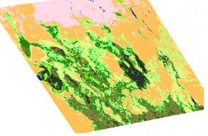
Land cover map 2014

The Central Asia research team at the Department of Remote Sensing, Würzburg University, recently started investigating potential risk areas for infestation of the Asian Migratory locust, Locusta migratoria migratoria L., in the Aral Sea basin.

Asian Migratory locust is a serious crop pest in the Amudarya River delta near the Aral Sea in Uzbekistan, Central Asia. Its economic importance increased after desiccation of the Aral Sea. Vast areas of the former sea bottom became covered with stands of common reeds Phragmites australis, which are well-known as the main breeding locust habitat in this region.  In order to enable efficient locust monitoring, accurate information about the spatial distribution of reeds is essential.

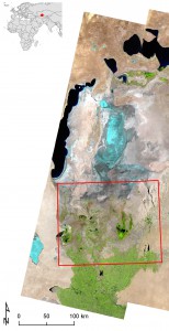
Aralsea_studyarea_Fabian_Loew

Study area in the lower Amudarya delta

Traditional ground-based locust monitoring is hardly possible in most areas of the delta, particularly on the former sea bottom. Due to its high revisit frequency, adequate spectral resolution and synoptic coverage, data from the MODIS satellite sensor aboard the Terra and Aqua platforms can provide the required information about spatio-temporal reed distribution in the Amudarya delta.

Additional efforts are recently spent on extending the methodology to provide early detection of potential breeding habitats within the growing season, and to analyze the correlation of water inflow to the delta and the spatial extent of locust breeding habitats. The results are instrumental for predicting potential locust outbreaks and developing better targeted management plans.

First results of our research will be presented at the upcoming IGU conference in Moscow.

For more information regarding recent and future research activities in this field, or interest in B.Sc. or M.Sc. thesis, contact Dr. Fabian Löw from the Department of Remote Sensing in Würzburg.

you may also like:

Science Communication training with our NetCDA partners

Science Communication training with our NetCDA partners

Friday last week we had the chance to offer our NetCDF guests and partners various workshops on science communication. Depending on their previous knowledge, the participants in these workshops were able to expand their skills in the external representation and...

Project meeting NetCDA

Project meeting NetCDA

The first annual NetCDA project meeting took place in Würzburg on November 21st, 2024. Together with all German and West African partners from the West African Science Service Centre on Climate Change and Land Use (WASCAL), we have laid the foundation for our future...

The EORC can also be found on bluesky

The EORC can also be found on bluesky

We are active on various social media channels but in the last weeks we monitored a very strong increase of scientists joining bluesky and following our activities on that platform. Therefore we decided to be more active on bluesky and post regular news about our...

Blender GIS introduction

Blender GIS introduction

Within out EAGLE Earth Observation M.Sc. we also cover software applications which might not be used on a regular basis within our field of research but are sometimes highly useful to display our spatial data in a visually appealing way - and also potentially provides...

EAGLE presentation by Gökçe Yağmur Budak

EAGLE presentation by Gökçe Yağmur Budak

On November 26, 2024, Gökçe Yağmur Budak will present her internship results on " Leveraging Data-Driven Approaches for Seismic Risk Assessment in Istanbul " at 12:30 in seminar room 3, John-Skilton-Str. 4a. From the abstract: This internship aims to create time...