Derivation of application examples for sustainable land and water management in Central Asia using the WebGIS tool WUEMoCA
Supervisor: Dr. Maik Netzband (maik.netzband@uni-wuerzburg.de), Department of Remote Sensing, Institute of Geography and Geology, University of Würzburg
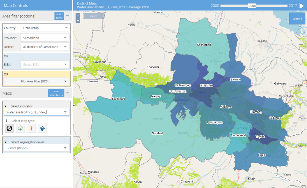
Objective: Where is the most water consumed for cotton farming in the Aral Sea basin? Where are the wheat yields highest? How has fallow land developed over the last 20 years? Such questions can be interactively answered by the WebGIS tool WUEMoCA (“Water Use Efficiency Monitor in Central Asia”). The developed indicator system is based on the requirements of regional water management, but also takes into account the UN Sustainable Development Goals (SDGs) “Food Security and Sustainable Agriculture” (SDG 2) and “Availability and Sustainable Water Management” (SDG 6).
WUEMoCA is a result of the CAWa project (see http://remote-sensing.eu/open-source-webgis-wuemoca-water-use-efficiency-monitor-in-central-asia/).
The bachelor thesis is aimed at:
- the spatio-temporal evaluation of the indicators retrievable in WUEMoCA (annual and long-term) and their discussion in the context of the SDGs (regional and global)
- the derivation of concrete application examples for the tool’s usage as well as the exploiting of these use cases to support decision-making processes in sustainable land and water management (e.g. identification of areas with high need of action).
Requirements:
- almost completed B.Sc. degree in the field of geographic remote sensing, geography or similar,
- preferable prior knowledge in remote sensing, spatial statistics, and geoinformation systems (not absolutely necessary),
- interest in issues of land and water resource management, irrigation agriculture in Central Asia, spatio-temporal data analysis, and discussion of indicators in the context of the UN Sustainable Development Goals.
Location: The place of work is freely selectable. Regular meetings with the supervisor and a presentation on the subject are mandatory.
Contact: Dr. Maik Netzband / Department of Remote Sensing / Institute of Geography and Geology / University of Würzburg / Phone +49 (0) 931 31 84922 / Email maik.netzband@uni-wuerzburg.de / https://www.geographie.uni-wuerzburg.de/fernerkundung/