updated RStoolbox version

updated RStoolbox version

January 29, 2016

The RStoolbox R package has been updated after some testing in courses and by colleagues. Please update your package using update.packages() or install the RStoolbox again.

New functions are:

  • new function `validateMap()` for assessing map accuracy separately from model fitting, e.g. after majority or MMU filtering
  • new function `getValidation()` to extract specific validation results of superClass objects (proposed by James Duffy)
  • new spectral index NDVIc (proposed by Jeff Evans)
  • new argument scaleFactor for `spectralIndices()` for calculation of EVI/EVI2 based on scaled reflectance values
  • implemented dark object subtraction radCor(..,method=’sdos’) for Landsat 8 data (@BayAludra, #4)

various changes were applied:

  • superClass() based on polygons now considers only pixels which have their center coordinate within a polygon
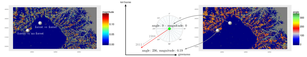
  • rasterCVA() now returns angles from 0 to 360° instead of 0:45 by quadrant (reported by Martin Wegmann and explained here)
  • improved dark object DN estimation based on maximum slope of the histogram in `estimateHaze` (@BayAludra, #4)

And some bugs fixed:

  • superClass() failed when neither valData or trainPartition was specified. regression introduced in 0.1.3 (reported by Anna Stephani)
  • spectralIndices() valid value range of EVI/EVI2 now [-1,1]
  • radCor() returned smallest integer instead of NA for some NA pixels
  • fix ‘sdos’ for non-contiguous bands in radCor (@BayAludra, #4)

follow us and share it on:

you may also like:

EORC at Space Summit Munich

EORC at Space Summit Munich

Yesterday, the space tech incl the remote sensing community gathered in the historic halls of Neues Rathaus München for the annual Space Summit Munich - an event that brought together scientists, industry leaders, and policymakers to discuss the future of Earth...

Empowering Biology Students with Open-Source Spatial Data Skills

Empowering Biology Students with Open-Source Spatial Data Skills

At EORC, we believe that spatial thinking and geodata literacy are becoming essential skills across scientific disciplines. This semester, we had the pleasure of contributing to the Biology MSc programs MERGE and other study tracks at the Biology Institute through a...

EAGLE M.Sc. Students doing Arctic Internship

EAGLE M.Sc. Students doing Arctic Internship

This spring, Marlene and Aoibhin, two students from our EAGLE M.Sc. program have started their research internship in the high Arctic on Svalbard. Hosted by Prof. Larissa Beumer at the University Centre in Svalbard (UNIS), the students are gaining hands-on experience...

EORC at the Smart Forest Conference: Research meets Practive

EORC at the Smart Forest Conference: Research meets Practive

This week, our EO4CAM staff Sonja and Julian attended the Smart Forest Conference in Freising, a meeting that brings together researchers, forestry practitioners, and technology developers working at the interface of forest science and digital innovation. Over two...

EO4CAM Data Portal Launched to Support Climate Adaptation in Bavaria

EO4CAM Data Portal Launched to Support Climate Adaptation in Bavaria

New Earth observation platform provides satellite-based information for public authorities and planners A new Earth observation data portal is bringing satellite-derived environmental information closer to climate adaptation planning. On 9 March 2026, the EO4CAM data...

Demography Meets Spatial Analysis: Insights from today’s EORC Talk

Demography Meets Spatial Analysis: Insights from today’s EORC Talk

A recent EORC Talk at the Earth Observation Research Cluster (EORC) at the University of Würzburg brought together perspectives from demography, geography, and spatial analysis. Sebastian Klüsener and Tamilwai Kolowa from the Federal Institute for Population Research...

Share This