New RapidEye datasets granted from RESA platform of DLR/Black Bridge

New RapidEye datasets granted from RESA platform of DLR/Black Bridge

July 14, 2015

The Dept. of Remote Sensing recently applied for a time series of 7 RapidEye scenes to support a PhD thesis by M.Sc Omid Karami (Sari University of Agricultural and Natural Resources Sciences, Iran). The proposal is now accepted, and th PhD work will be supported by a time series of RapidEye scenes acquired between 07.2009 and 09.2014 over a semi-Meditteranean forested site in Lorestan province in Western Iran.

The PhD thesis which will use these processed datasets is entitled  “Monitoring and modelling of Zagros forest oak decline using high resolution satellite data”, supervised and advised by Dr. Asghar Fallah (Sari University of Agricultural and Natural Resources Sciences), Dr. Shaban Shataee (University of Gorgan) and Dr. Hooman Latifi (University of Würzburg). Additional multisource datasets to be used within the work include very high resolution data from Quickbird and World View-2.

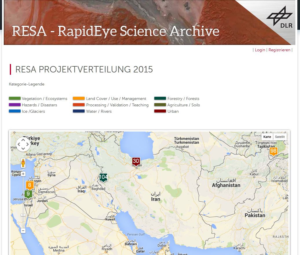
RESA already published this project in RESA project map 2015 which can be found online HERE. The project area is flagged under No. 104 (project number 168) in the map.

resa_iran

The RapidEye Science Archive (RESA) supported by DLR (BMWi) and Black Bridge AG supports scientific projects with German participation through the provision of free image data of the RapidEye satellite constellation. The projects are given the opportunity on an extensive image archive to get current and archived satellite image data to ensure optimal support for individual research projects.

you may also like:

Xmas sweet tasting event

Xmas sweet tasting event

Our PostDocs organised a Xmas season tasting event with more than 10 different typical German sweets usually served in the pre-mas season.  Various dishes were prepared by them or ordered from the place of origin eg lebkuchen, aachener printen or stollen from eg...

Research on the UFS

Research on the UFS

The Earth Observation Research Cluster (EORC) is already conducting research on and around the highest mountain of Germany, Zugspitze and from next year our University will also be formally affiliated with the research station at Zugspitze (UFS). We are very much...

Contribution to the Geo-IT podcast of gis.Radio

Contribution to the Geo-IT podcast of gis.Radio

  For a new contribution to the Geo-IT podcast gis.Radio, Andreas Eicher interviewed our Professor Hannes Taubenböck about his recent talk at the Geographic Society Würzburg. We have reported on this talk:...

R package for Migration Analysis released

R package for Migration Analysis released

R package for Migration Analysis released We are happy to announce the initial release of our MigrationDetectR package. The package has been developed by Johannes Mast and applied as part of our work in the MIGRAWARE project. It is now released as part of the DLR...