Open research position at the Department of Remote Sensing, “UPSCALE” project

Open research position at the Department of Remote Sensing, “UPSCALE” project

July 10, 2020

The Department of Remote Sensing at the Julius-Maximilian-University of Würzburg (JMU), Germany, offers an open research position starting on 01 November 2020.

The research position is to be awarded half-time and is initially limited for 3 years until 31 October 2023. The remuneration is based on the TV-L.

The successful applicant will work in an international team and will be predominantly involved in the following project activities within the recently procured European Commission funded project “UPSCALE”:

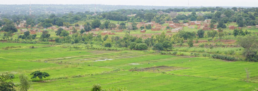
  • Mapping of biophysical parameters and farming systems in East Africa,
  • Analysis of very high spatiotemporal resolution optical images,
  • Documentation of the developed methodology,
  • Fieldwork in East Africa (Ethiopia, Kenya, Tanzania, Uganda, Rwanda),
  • Supporting the project lead, and
  • Preparation of scientific publication

The following qualifications are required:

  • A university degree in natural sciences in the field of geography, geomatics, or similar, with a focus on spatial data analysis,
  • Excellent programming skills (Python, R),
  • Willingness to work in an international team and project and in travel activities (national/international), very good organizational skills, and high motivation to work independently,
  • Very good English language skills both written and oral, and
  • Opportunity to obtain a doctorate is provided

The JMU aims to increase the proportion of women and therefore explicitly encourages qualified women to apply. Disabled persons are given preferential employment if their eligibility, skills and professional performance are essentially equal.

Please send your application documents with reference to the keyword LSFE-UPSCALE – also by e-mail – by 02 August 2020 to

Dr. Michael Thiel, Lehrstuhl für Fernerkundung, Oswald-Külpe-Weg 86, 97074 Würzburg
l-geofernerkundung@uni-wuerzburg.de

Please send copies only. For financial reasons, the application documents cannot be returned and will be destroyed shortly after the end of the selection procedure. If you enclose a stamped envelope, the application documents will be returned to you three months after the end of the selection procedure.

follow us and share it on:

you may also like:

Starkregen in Bayern: Beobachtungen und Dokumentation zählen

Starkregen in Bayern: Beobachtungen und Dokumentation zählen

Starkregenereignisse treten immer häufiger lokal, kurzfristig und mit hoher Intensität auf. Innerhalb weniger Stunden können sie erhebliche Überschwemmungen und Schäden verursachen. Um solche Ereignisse künftig besser zu verstehen und die wissenschaftliche Grundlage...

Seeing the World in Points: Lidar Course for the EAGLEs

Seeing the World in Points: Lidar Course for the EAGLEs

Lidar has a funny way of sneaking up on you. You think you know what it is, a laser that measures distance, fine, but then someone shows you a point cloud of a forest canopy with individual branches floating in 3D space and suddenly you realize there's a whole...

RTL covers EORC: TV Crew Films MONID Habitrack Fieldwork

RTL covers EORC: TV Crew Films MONID Habitrack Fieldwork

A bit of extra excitement at EORC recently, an RTL television crew showed up to film a segment on the MONID Habitrack project, and Dr. Ariane Droin was right in the middle of it, walking them through what Earth Observation actually brings to the table for a project...

Ticks from Above: UAS Fieldwork for the MONID Habitrack Project

Ticks from Above: UAS Fieldwork for the MONID Habitrack Project

Forest edges are tricky places. They're where woodland meets open ground, where light and shade trade off every few meters, and where, it turns out, ticks tend to do really well. That last bit is exactly why Dr. Ariane Droin, Sofica Garcia de Leon, Dr. Jakob...

Course on urban EO by Michael Wurm

Course on urban EO by Michael Wurm

Walk through any city and you pick up on things that are hard to put a number on. The noise of a main road, the heat that sits between buildings in summer, the question of whether that little park around the corner is really enough green space for the whole...

EireR R package: unified gateway to Irish geospatial data

EireR R package: unified gateway to Irish geospatial data

Anyone who's tried to do geospatial work across the whole island of Ireland knows the headache. Ireland is one island geographically, but it's split across two jurisdictions, the Republic and Northern Ireland, and each one runs its own data infrastructure. Different...

Share This