rsMove R package update!

rsMove R package update!

January 24, 2018

An update for rsMove is now available on CRAN. rsMove was designed to support movement ecologists in the selection and handling of remote sensing data. This package helps select study sites, guides the choice of satellite data by quantifying the influence of its spatial and temporal resolutions on movement data and quantifies species-environment interactions to help choose environment variables. Additionally, rsMove provides tools to homogenize the scales of remote sensing and animal movement data, select presence/absence samples and model resource suitability from a remote sensing perspective (see Remelgado et al., 2017). Most of the functions in rsMove are accompanied by ggplot objects providing the users with editable plots. This release significantly improves function descriptions and keywords. Moreover, we included a vignette with practical examples! To acces it, click here.

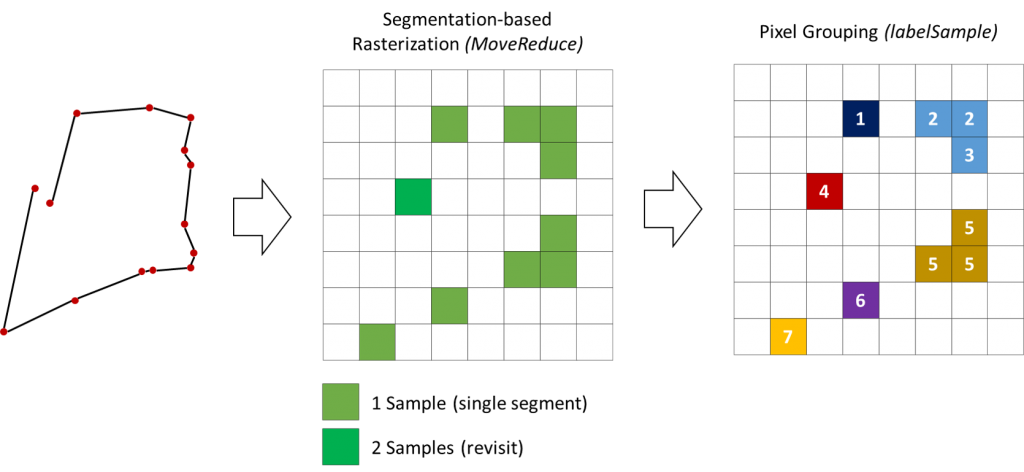
translation of movement data (on the left) to pixels that preserve revisits (center) – to adress pseudo-replication – and the subsequent split of training samples based on their connectivity (right) – to address spatial autocorrelation.

you may also like:

Our research site and project covered by BR

Our research site and project covered by BR

The University forest at Sailershausen is a unique forest owned by the University of Wuerzburg. It comes with a high diversity of trees and most important is part of various research projects. We conducted various UAS/UAV/drone flights with Lidar, multispectral and...

Meeting of the FluBig Project Team

Meeting of the FluBig Project Team

During the last two days, the team of the FluBig project (remote-sensing.org/new-dfg-project-on-fluvial-research/) met at the EORC for discussing the ongoing work on fluvial biogeomorphology. After returning from a successful field expedition to Kyrgyzstan a couple of...

‘Super Test Site Würzburg’ project meeting

‘Super Test Site Würzburg’ project meeting

After the successful "Super Test Site Würzburg" measurement campaign in June (please see here: https://remote-sensing.org/super-test-site-wurzburg-from-the-idea-to-realization/ ), the core team from the University of Würzburg, the Karlsruhe Institute of Technology,...

EORC Talk: Geolingual Studies: A New Research Direction

EORC Talk: Geolingual Studies: A New Research Direction

On July 19th, Lisa Lehnen and Richard Lemoine Rodríguez, two postdoctoral researchers of the Geolingual Studies project, gave an inspiring presentation at the EORC talk series.   In the talk titled "Geolingual Studies – a new research direction", they...

EO support for UrbanPArt field work

EO support for UrbanPArt field work

From May to September, Karla Wenner, a PhD student at the Juniorprofessorship for Applied Biodiversity Science, will be sampling urban green spaces and semi-natural grasslands in Würzburg as part of the UrbanPArt project. Our cargo bikes support the research project...

Cinematic drone shots

Cinematic drone shots

We spend quite some time in the field conducting field work, from lidar measurements to vegetation samples in order to correlate it with remote sensing data to answer various research questions concerning global change. Field work is always a 24/7 work load and...