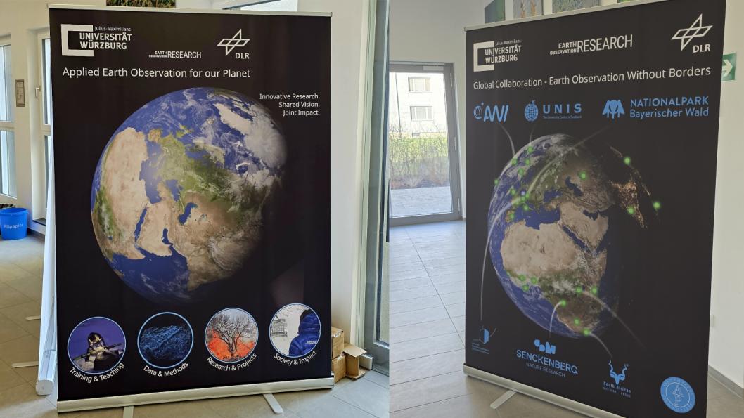

Our Earth Observation Research Centre (EORC) at the University of Würzburg is involved in many collaborations applying remote sensing to environmental monitoring, conservation, and ecosystem research. Our work spans mountain ranges, forests, savannahs, and protected areas across continents, leveraging satellite imagery, drones, and advanced spatial analytics to inform science, policy, and management.
Key to our success is strong international collaboration. Together with global partners, we combine expertise in ecology, geoinformatics, biodiversity, and climate science to tackle some of the most pressing challenges in environmental monitoring and conservation. On our most recent roll-up just a small fraction of our collaborations are listed but many more are active, highly profile collaborators – some details about just the ones that are listed on our roll-up (of course we missed many other important collaborators but the ones below fitted very well with their geographic location on our design – a decision we had to make … ):
Alfred Wegener Institute (AWI) – Polar and Climate Research
Collaboration with the Alfred Wegener Institute focuses on polar ecosystems, cryosphere monitoring, and climate-sensitive environments. Our joint projects integrate satellite-based snow and ice monitoring, UAV surveys, and geospatial modeling to study snow dynamics, glacier changes, and their impact on local ecosystems. These efforts inform both fundamental science and climate adaptation strategies in Alaska, North Canada, Greenland or Svalbard.
University Centre in Svalbard (UNIS) – Arctic Observation
With the University Centre in Svalbard, our collaboration extends to Arctic monitoring. Together we explore high-latitude snow and ice dynamics using remote sensing and UAV-based field campaigns. These studies help quantify snow depth, snowpack properties, and seasonal changes critical for understanding Arctic climate processes and their downstream impacts.
Nationalpark Bayerischer Wald – Forest Ecosystem Monitoring
Partnership with the Nationalpark Bayerischer Wald leverages Earth observation for forest health assessment, biodiversity mapping, and ecosystem monitoring. Using drone surveys and satellite imagery, we track forest structure, tree mortality, and regeneration dynamics over time. This approach enhances conservation planning and supports long-term ecological research in Europe’s oldest national park.
South African National Parks (SANParks) & African Parks – Wildlife and Habitat Monitoring
In collaboration with South African National Parks and African Parks, EORC applies remote sensing to savannah ecosystems, protected area management, and wildlife monitoring. Our joint projects use satellite imagery and UAV data to map land cover changes, habitat fragmentation, and human-wildlife interactions, helping to guide conservation interventions and park management decisions across Africa.
Senckenberg Nature Research Society – Biodiversity and Landscape Studies
Together with the Senckenberg Nature Research Society, we integrate Earth observation with ecological and biodiversity datasets. This collaboration focuses on tracking habitat change, forest degradation, and landscape-level biodiversity patterns, providing data that informs both national and international conservation policies.
UFS Schneefernerhaus – Alpine Ecosystem Research
The Schneefernerhaus Research Station provides a unique high-altitude laboratory for studying mountain ecosystems. Working together, we combine UAV-based snow and vegetation surveys with satellite-derived climate data to monitor alpine snow cover, vegetation phenology, and glacier dynamics. These insights support both climate research and ecological monitoring in fragile high-mountain environments.
EORC Partnerships in Action: Bridging Technology and Conservation
Across these collaborations, the common thread is the use of remote sensing as a bridge between scientific disciplines and geographies. By integrating satellite imagery, UAV surveys, and advanced geospatial modeling, EORC and its partners can:
-
Detect ecosystem changes in near real-time
-
Map biodiversity and habitat structures at high resolution
-
Monitor conservation areas across different climate zones
-
Inform policy and management decisions with accurate, timely data
From the frozen landscapes of the Arctic to the savannahs of Africa and the forests of Bavaria, these partnerships demonstrate the global potential of Earth observation to support conservation and sustainable ecosystem management.
Looking Forward
As environmental pressures grow, remote sensing and collaborative research become ever more critical. EORC’s international network enables cross-disciplinary learning and fosters innovative solutions for global conservation challenges. Together with AWI, UNIS, SANParks, African Parks, Senckenberg, UFS Schneefernerhaus, and other partners, we continue to expand our capabilities, ensuring that conservation efforts are grounded in robust, data-driven insights.