New publication: Forest inventories by LiDAR data: A comparison of single tree segmentation and metric-based methods for inventories of a heterogeneous temperate forest

New publication: Forest inventories by LiDAR data: A comparison of single tree segmentation and metric-based methods for inventories of a heterogeneous temperate forest

m

July 16, 2015

A new paper led by the Dept. of Remote Sensing presents an in-depth insight into practical implementations of a fullwave LiDAR survey for deriving essential forest structural variables on landscape scale. Carried out in the entire territory of Bavarian Forest National Park in Germany, this work evaluated two fundamentally-different methods of forest inventory that use LiDAR data at the landscape level: the single tree segment-based method and an area-based method. A set of structural forest attributes were modeled by these methods with a conventional forest inventory of the highly heterogeneous forest landscape which partially includes stands affected by severe natural disturbances.
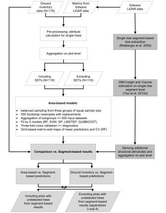
Methodology adopted to the study

The single tree-based algorithm delivered highly reliable estimates of variables and their uncertainty for a set of forest structural attributes that are of interest in forest inventories at the landscape scale. This was also well correlated with the results obtained form traditional metric-based LiDAR models as well as with those form field-based forest inventory. Based on the obtained results, this work recommends LiDAR forest inventories at the landscape scale in both heterogeneous commercial forests and large protected areas in the central European temperate sites.


Latifi, H., Fassnacht, F.E., Müller, J., Tharani, A., Dech, S., Heurich, M. 2015. Forest inventories by LiDAR data: A comparison of single tree segmentation and metric-based methods for inventories of a heterogenuous temperate forest. Int. J. Appl. Earth Obs. Geoinf. doi:10.1016/j.jag.2015.06.008


follow us and share it on:

you may also like:

DBU scholar Josipa Subotic

DBU scholar Josipa Subotic

Almost a year ago, Josipa Subotic showed up at EORC as a DBU scholar, and now her stay with us is coming to an end. Josipa spent her time digging into snow cover properties around the Zugspitze, working with Sentinel-2 time series data. Multispectral imagery, lots of...

GLS-team visits Planetary Health exhibition

GLS-team visits Planetary Health exhibition

One of the aims of Geolingual Studies Geolingual Studies - Geolingual Studies is to ensure effective science communication beyond the scientific community and into the wider society. The Geolingual Studies team was given the opportunity to look at concepts and methods...

University press covered our anniversaries

University press covered our anniversaries

Einblick, the University of Würzburg's press medium, published an article on our double anniversary, 25 years of Earth observation research and 10 years of EAGLE M.Sc. program, today. Recently, they has visited us at our EORC to hear about our research and teaching...

Mapping Lava Tubes on Mauritius with iPhone Pro LiDAR

Mapping Lava Tubes on Mauritius with iPhone Pro LiDAR

Lava tube structures on Mauritius are quite hard to survey - tight, dark, and largely inaccessible to classical scanning equipment. As part of ongoing research by Dr. Kim Lea Holzmann (Chair of Animal Ecology and Tropical Biology, University of Würzburg), we're...

Johannes Mast wins Bernd Rendel Prize

Johannes Mast wins Bernd Rendel Prize

Johannes Mast is awarded the 2026 Bernd Rendel Prize for Geosciences by the Deutsche Forschungsgemeinschaft (DFG) for outstanding research as part of his dissertation. Johannes’s highly interdisciplinary work bridges the Geosciences, Linguistics, Data Science, and...

Share This