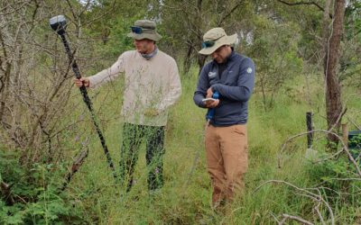
Understanding how agriculture can adapt to a changing climate is one of the key challenges of our time. At EORC, we are pleased to share that our researchers are currently collaborating with the Bavarian State Research Center for Agriculture (LfL) on an innovative project that leverages unmanned aerial systems (UAS) and advanced sensor technologies.
This joint effort focuses on collecting and analyzing multi-temporal datasets using a combination of multispectral, thermal, LiDAR, and hyperspectral sensors mounted on UAS platforms. By integrating these diverse data sources with in-situ field measurements, the project aims to better understand how different agricultural practices perform under varying environmental and climatic conditions.
A central aspect of the research is the development of time series that capture crop responses across growing seasons. These datasets enable detailed assessments of plant health, water stress, biomass development, and structural characteristics. Such insights are essential for identifying resilient farming strategies and supporting evidence-based climate adaptation measures.
The project also benefits from close collaboration with local farmers, who generously provide test sites and practical perspectives. Their involvement ensures that the research remains grounded in real-world agricultural challenges and helps bridge the gap between scientific innovation and practical application.
This partnership represents an important step toward more sustainable and climate-resilient agricultural systems, combining cutting-edge remote sensing technologies with on-the-ground expertise.
Further details on our hyperspectral, multispectral, and LiDAR-based UAS research in agricultural contexts will be shared soon – stay tuned.