CornXplain: User Friendly App to Predict Corn Yields in the USA

CornXplain: User Friendly App to Predict Corn Yields in the USA

m

December 7, 2022

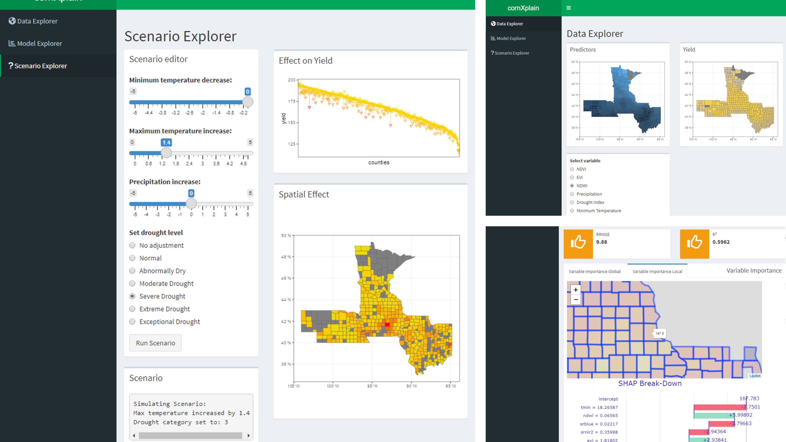
Accurate Crop Yield Prediction Using Satellite Remote Sensing is Hard? No, It’s not anymore. My colleague Johannes Mast and I developed a user-friendly crop yield app (cornXplain) that can predict future yields for precision agriculture and sustainable agriculture at higher accuracy. Currently, the app works for Maize (/Corn) crops; however, it can potentially adapt to other crop types like the winter wheat, soybean, and rapeseed. So far, cornXplain has three parts:

1) Data Explorer: where the user can visualize the spatial pattern of #climate or biophysical variables,

2) Model Explorer: where the user can see the inner details of the model.

The model combines a physical model (Light use efficiency) and machine learning (random forest ). The model predicts yield at the county level for five corn-growing states (Iowa, Illinois, Nebraska, Minnesota, and Indiana) in the USA. Users can also see the impact of biophysical and climate variables on crop yield prediction for different counties, and

 3) Scenario Explorer: where the user can play around with multiple scenarios. For example, what will impact crop yield if the temperature rises by 2 degrees Celsius or rainfall decreases by 20%?

Data used: MODIS (500m, eight days), Climate Variables and Indices (Temperature, Precipitation, Drought Index, Heat and Cold Index), Biophysical Parameters (Lead Area Index (lai), Fraction of Photosynthetically Active Radiation (fpar)) and Crop Yields (bushels/acre).

The data was provided by ML4Earth Hackathon 2022.

This information will be helpful for the remote-sensing agricultural community. We are glad to share our code for future research purposes, and it is available on our GitHub. Our relevant publication on a similar topic would be out soon.

For more information, feel free to contact us.

Written By: Maninder Singh Dhillon


you may also like:

welcome of the new EAGLE Earth Observation students

welcome of the new EAGLE Earth Observation students

Today our new EAGLE students were welcomed and introduced to our remote sensing work. Tobias Ullmann presented various remote sensing projects at our EORC from Africa to the Arctic and also outlined our structure. Martin Wegmann introduced the general concept of EAGLE...

EORC at the Annual Meeting of the German Society for Geomorphology

EORC at the Annual Meeting of the German Society for Geomorphology

From Wednesday to Friday, EORC scientists Baturalp Arisoy and Florian Betz participated in the annual meeting of the German Society for Geomorphology which took place at the University of Leipzig. EORC showed two posters on "High performance Desert Analytics:...

Science slam with Earth Observation

Science slam with Earth Observation

On November 8th the University Wuerzburg Science Slam will take place on the Campus Hubland again - this time with the head of our Department of Global Urbanization and Remote Sensing, Prof. Hannes Taubenboeck. He will present our urban research using remote sensing...

new team member Lilly Schell

new team member Lilly Schell

Lilly Schell joined the Earth Observation Research Cluster in October 2024 as a research assistant for the “Network for Capacity Development in Climate Change Adaptations in Africa” project. Her doctoral research will focus on the use of remote sensing techniques in...

Research by Jannis Midasch presented at Archaelogy conference

Research by Jannis Midasch presented at Archaelogy conference

Our EAGLE student Jannis Midasch presented his work on "Rediscovering a lost medieval castle using GIS and UAS-based remote sensing" at the Annual Meeting of the Aerial Archaelogy Research Group in York, UK this September. Jannis used various UAS/drone based...