


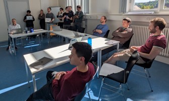
This week Thorsten Hoeser, an expert in deep learning and data science, taught AI methods in remote sensing at our International EAGLE Earth Observation MSc Program. In this special module, Thorsten covered essential topics on the cutting-edge techniques for implementing scalable deep learning pipelines using PyTorch on the DLR High-Performance Computing cluster, Terrabyte.
Thorsten’s sessions dived into advanced areas of deep learning, providing students with hands-on experience in utilizing the high-performance resources of the DLR cluster to train models efficiently at scale. The focus of the module included:
-
Implementing Scalable Deep Learning Pipelines with PyTorch: Students learned how to leverage the DLR Terrabyte cluster to accelerate model development and handle massive datasets for Earth observation tasks.
-
Experiment Tracking and Training Metrics Interpretation: Thorsten guided students on how to manage and track their experiments effectively. Participants learned to interpret key training metrics for improved decision-making and model performance optimization.
-
A Data-Centric Approach to Model Training and Improvements: Moving beyond traditional model-centric views, Thorsten emphasized the importance of data quality and optimization. This perspective will enable students to understand how to refine and improve models through careful data manipulation and understanding.
This training, powered by the DLR Terrabyte cluster, aims to equip students with the skills needed to implement robust, scalable, and efficient deep learning solutions, critical for addressing complex Earth observation challenges.
follow us and share it on:
you may also like:
Hackathon within the Super-Test-Site Project
What happens when researchers and developers sit down together to explore a multidisciplinary urban dataset? Our researchers from the EORC joined a hackathon that took place within the Super-Test-Site Project, organised by Prof. Dr. Gunther Gust from the Chair of...
Field Days in the Oberpfalz: Exploring FSME Hotspots
On April 17th and 29th our researchers Sofía and Ariane had two field days in the areas around Amberg and Schwandorf, one of Germany's most well-known TBE (tick-borne encephalitis) risk regions. They joined Prof. Dr. Gerhard Dobler and Dr. Lidia Chitimia-Dobler from...

UAV LiDAR campaign by EORC & UNIS in the remote valleys of Reindalen & Semmeldalen
The Arctic Tundra on Svalbard is a fascinating ecosystem: The soil is covered by a large variety of plants during the summer, fueled by the light of the never-setting sun, painting Svalbard‘s valleys and slopes green. Then, with the arrival of the Arctic winter, snow...

Johannes Mast has successfully defended his PhD Thesis
Johannes Mast defended his PhD Thesis titled "Geographical Migration Research using Remote Sensing and Social Media Data" at the Julius-Maximilians-University Würzburg successfully on the 29th of April 2026. We congratulate him very much for his...
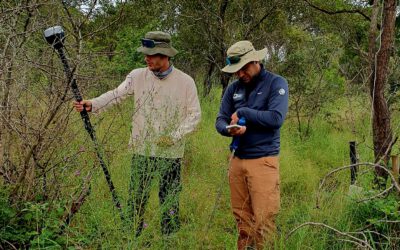
EAGLEs at SANParks – Kruger National Park
Our EAGLEs Sebastian Rothaug and Clemens Schömig just finished their 2+ months for the internship/InnoLab in Kruger National Park. The work was done with SANparks, Dr. Coetsee and Dr. Wigley within a year-long collaboration of EORC researcher Dr. Bevanda. The...

Fieldwork in Focus: Our New “Hex Wall” Installation
At EORC, the transition from physical reality to digital analysis is a core part of our methodology. While our primary output consists of Earth Observation data the foundation of this work is laid in the field. To document this essential aspect of our research, we...