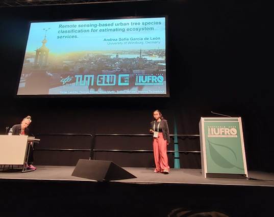
Last week, Andrea Sofía García represented our Earth Observation Research Cluster (EORC) at the IUFRO World Congress in Stockholm, Sweden (iufro2024.com). The event, which attracted over 4,000 experts and practitioners from around the globe, served as a dynamic platform for discussing the latest scientific advancements in forestry.
Sofía showcased our research on a remote sensing-based urban tree species classification for estimating ecosystem services. This research was developed as part of the project “Ecosystem Services of the Urban Forest: Area-wide Modeling Based on Remote Sensing and Artificial Intelligence,” funded by the Deutsche Bundesstiftung Umwelt (DBU).
In addition to presenting her research, Sofía participated in several insightful presentations and excursions that deepened her understanding of the relation between forest and society. These experiences not only enhanced her knowledge but also provided her with valuable networking opportunities with fellow forestry professionals and experts. The IUFRO World Congress proved to be an invaluable experience, allowing us to share our research with a global audience and to learn from the cutting-edge work being done by others in the field.
The abstract of Sofia’s presentation is included below.
Title: Remote sensing-based tree species classification for estimating ecosystem services
Session: Urban trees & green landscapes: Monitoring and management for providing multiple services
Authors: Andrea Sofia Garcia de Leon, Tobias Leichtle, Thomas Rötzer, Klaus Martin, Tobias Ullmann, Hannes Taubenböck
Urban trees play a vital role in enhancing community health and well-being by providing environmental, social, and economic functions, collectively known as ecosystem services. Urban tree growth models have attempted to estimate the extent of these ecosystem services using allometric equations, growth factors and physiological functions. Nevertheless, these models require detailed information on individual tree characteristics, particularly tree species. Traditional data collection methods for tree attributes can be expensive and time-consuming. This study proposes a cost-effective approach utilizing remote sensing products, specifically multi-temporal satellite imagery and a canopy height model with very high spatial resolution, in conjunction with machine learning techniques for single tree classification.
Our classification method incorporates various features, including vegetation indices, spectral, geometrical, and phenological attributes to differentiate the most common tree genera in Munich, Germany. To enhance classification accuracy, we adopt a hierarchical approach that considers land use, physiological characteristics, genus, and species. The model was applied over a large-scale area, successfully classifying more than 160,000 trees. Evaluation of the results revealed variations in classification accuracy based on land use and tree genus, achieving an accuracy of up to 88 % for certain species. Our results are further validated for the estimation of ecosystem services by testing our tree metrics in the CityTree model.
This research demonstrates the efficacy of remote sensing and machine learning techniques for accurately classifying urban trees and obtaining detailed tree attributes necessary for ecosystem services models. The findings contribute to a more detailed understanding of urban tree dynamics and provide valuable insights for monitoring urban trees and their ecosystem services.