
In a new publication titled “Multi-disciplinary constraints on the onset and early evolution of the May 2026 Titan Ridge submarine eruption, the potential of combining seismic, hydroacoustic, and satellite-based observations for the detection and characterization of remote shallow submarine eruptions in tectonically complex and sparsely monitored oceanic environments was demonstrated.
This research was a joint undertaking by an international team of researchers from the Earth Observation Center (EOC) of the German
Aerospace Center (DLR), the Goethe University Frankfurt, the National Research Council in Potenza, the Politecnico di Milano, the Earth Observation Research Cluster (EORC) of the University of Würzburg, the GFZ Helmholtz Centre for Geosciences in Potsdam, the GEOMAR Helmholtz Centre for Ocean Research Kiel, the University of Rochester and the Pennsylvania State University. The study was just published in the Journal ‘Bulletin of Volcanology’ by Simon Plank, Georg Rümpker, Fabian Limberger, Emanuele Ciancia Francesco Marchese, Nicola Genzano, Hannes Taubenböck, Sandro Martinis, Thomas R. Walter, Philipp A. Brandl, SayanSwar, Tolulope Olugboji and Tushar Mittal.
Here is the Abstract
of the paper: The onset and early evolution of submarine volcanic eruptions are rarely observed directly, limiting our understanding of the processes that govern shallow marine volcanism. Here, we reconstruct the first 3 weeks of the May 2026 eruption of Titan Ridge Volcano,
Bismarck Sea, Papua New Guinea from a large multi-disciplinary dataset: regional seismic records, a hydroacoustic array at 3159 km range, and multi-sensor satellite imagery. Coherent acoustic radiation began at 08:04 UTC on May 8, 17 min before the first regional seismic
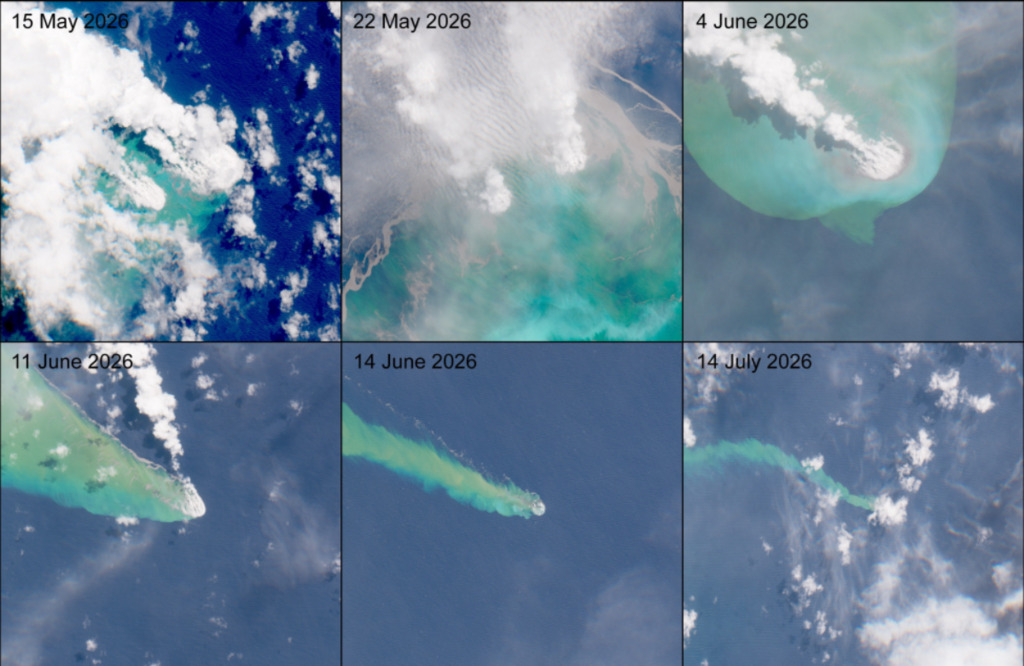
detection, 4 h before the largest earthquake, and 17 h before any surface expression was visible from orbit. The combination of hydroacoustic array data with high spatial resolution satellite data enables both precise timing of acoustic onset and precise location of the eruption source.
Multi-sensor satellite observations document two upwelling zones located ~ 2.5 km apart atop the volcanic eruption, and track their migration over time. The sea-surface features suggest that the discolored-water and pumice-raft products were sourced from multiple eruptive vents. These vents fed pumice rafts giving a dense-rock-equivalent volume of at least 0.011 to 0.014 km³ and a time-averaged discharge of order 10^4 kg s−1, from a pre-eruption vent depth of 400 to 700 m. Our study demonstrates the potential of combining seismic, hydroacoustic, and satellite-based observations for the detection and characterization of remote shallow submarine eruptions in tectonically complex and sparsely monitored oceanic
environments.
Read the full article
here: https://link.springer.com/article/10.1007/s00445-026-02056-7
Two popular science
websites have already reported on the paper:
- https://allatra.media/natural-disasters/natural-disasters-titan-ridge-eruption-onset
- https://www.forschung-und-wissen.de/nachrichten/geologie/unterseevulkan-titan-ridge-schickt-bims-300-kilometer-weit-133715297
This work is closely
related to previous works on the monitoring and analysis of
volcanic activity using Earth observation data – see here
for more information:
- https://remote-sensing.org/new-publication-on-the-growth-and-erosion-of-volcanic-islands-since-1963/