Last year, Prof Dr Christian Geiß submitted his habilitation at the University of Würzburg with the title “Collective sensing and artificial intelligence techniques for natural hazard risk and impact assessment“.
His habilitation colloquium has been set on Monday, 17 February 2025 – 14:00 in HS 4, Philosophy Building at the University of Würzburg. The topic of his colloquium is “Earth observation techniques for monitoring wars and conflicts“.
We cordially invite you all to the colloquium.
Christian Geiß studied geography and applied geoinformatics at the Friedrich-Alexander-University Erlangen-Nuremberg and the Paris-Lodron-University Salzburg and subsequently completed his doctorate at the Humboldt University in Berlin on the topic of “Seismic vulnerability assessment of built environments with remote sensing”. He heads the “Georisks” working group in the “Georisks and Civil Security” department at the German Remote Sensing Data Centre (DFD) of the German Aerospace Center (DLR) and is Professor of Georisks Research with Remote Sensing Methods at the Rheinische Friedrich-Wilhelms-Universität Bonn. Since March 2020, Christian Geiß has been pursuing a habilitation on the topic of “Collective information collection methods and artificial intelligence techniques for natural hazard-related risk assessments and damage estimates” at the Julius-Maximilians-Universität Würzburg.
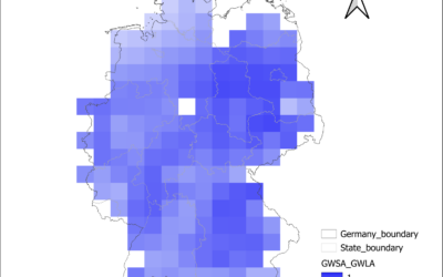
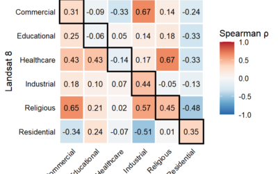
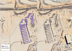
In his habilitation thesis, Christian Geiß focused on the interactions between natural hazards and settlement areas. From a data-oriented perspective, the testing and utilisation of modern earth observation missions played a central role in this interdisciplinary field of application. In addition, he used other relevant geodata sources, such as volunteered geographic information, geolocalised text-based data and image data at street level. On a methodological level, he adapted and developed techniques from the field of “machine learning/artificial intelligence” to extract thematic information from often multimodal data sources. With regard to the application of the data and techniques, he particularly analysed risks from natural hazards such as earthquakes, tsunamis, landslides and floods. A particular focus was on the quantitative mapping of future risk situations and image-based mapping of damage to the built and natural environment
The habilitation was mentored by chairman Prof Dr Stefan Dech, by Prof Dr Heiko Paeth, and by Prof Dr Hannes Taubenböck.