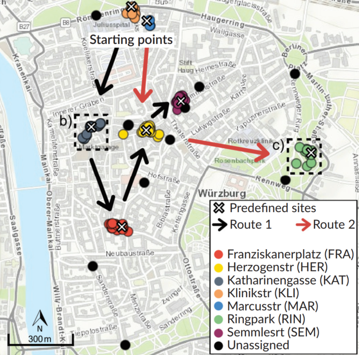

Three years ago, at the Geolingual Studies Workshop (see here: https://remote-sensing.org/geolingual-studies-workshop-day-1/) researchers from very different disciplines developed ideas to explore how we can better understand the relationship between people and urban spaces. This interdisciplinary collaboration led to a measurement campaign in Würzburg (see e.g. here: https://remote-sensing.org/super-test-site-wurzburg-from-the-idea-to-realization/ ) and now it resulted in our first joint peer-reviewed paper. This paper introduces a methodological framework for Spatial Decision Support (PDSS), exploring how objective spatial information and subjective urban experiences can jointly inform urban planning.
The paper entitled “From Spatial to Platial Decision Support: A Methodological Digital Framework for Urban Experience” has just been published in the journal Urban Planning by Nils Karges, Dominik Kremer, Peter Zeile, Lisa Lehnen, Richard Lemoine-Rodríguez, Ignacio Ubeda Soto, Andreas Neuner, Matthias Gamer, Jürgen Rauh, Marco Schmidt, Gunther Gust, Birgit Wallmann-Sperlich, Ariane Droin, Ninja Schulz, Carolin Biewer and Hannes Taubenböck. The team covers the fields of remote sensing, (geo)-informatics, computer science, urban planning, social geography, linguistics, digital humanities, psychology, business informatics and sports science.
Please find the full paper here: https://doi.org/10.17645/up.12665
Here is the abstract of the paper: Urban planning increasingly seeks to account for how urban spaces are experienced and interpreted by city dwellers and visitors, yet experiential dimensions remain only weakly integrated into planning decision support. This article presents a proof‑of‑concept implementation of a platial decision support system (PDSS) that structures diverse forms of in situ, human‑generated evidence into a planning‑oriented analytical framework. The PDSS operationalises these observations through four analytical levels of increasing resolution. An environmental context layer, together with aggregated self-reported appraisals, establishes a structural baseline for identifying locations that warrant deeper investigation. Level 1 documents salient sensory cues through visual and acoustic observations, while Level 2 interprets these cues through individual and group-specific sense-making, transforming multimodal observations into shared empirical evidence of experiential conflicts, affordances, and planning-relevant priorities. A conceptual Level 3 situates this evidence within planning deliberation, where it can inform stakeholder negotiation and the implementation of planning measures. The framework is demonstrated using a case study in Würzburg, Germany. Results show that locations with comparable environmental characteristics and aggregated appraisal can nevertheless differ substantially in how they are perceived, interpreted, and prioritised by different user groups. Rather than prescribing planning solutions, the PDSS provides a transparent and scalable workflow that translates multimodal urban observations into shared empirical evidence, complementing established spatial analyses and supporting planning deliberation through structured, context-sensitive, and evidence-informed urban planning.