New Publication: Exploring the Potential of C-Band SAR in Contributing to Burn Severity Mapping in Tropical Savanna

New Publication: Exploring the Potential of C-Band SAR in Contributing to Burn Severity Mapping in Tropical Savanna

January 8, 2020

I’m pleased to share my first publication to the Open Access Journal Remote Sensing together with Shaun Levick.

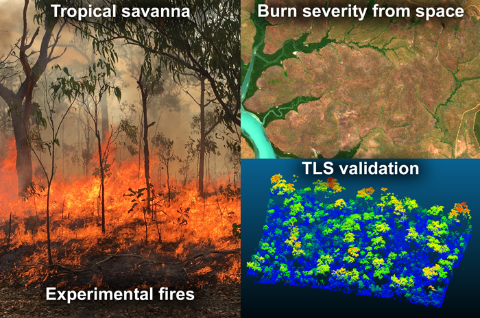
From the abstract: “The ability to map burn severity and to understand how it varies as a function of time of year and return frequency is an important tool for landscape management and carbon accounting in tropical savannas. Different indices based on optical satellite imagery are typically used for mapping fire scars and for estimating burn severity. However, cloud cover is a major limitation for analyses using optical data over tropical landscapes. To address this pitfall, we explored the suitability of C-band Synthetic Aperture Radar (SAR) data for detecting vegetation response to fire, using experimental fires in northern Australia. Pre- and post-fire results from Sentinel-1 C-band backscatter intensity data were compared to those of optical satellite imagery and were corroborated against structural changes on the ground that we documented through terrestrial laser scanning (TLS). Sentinel-1 C-band backscatter (VH) proved sensitive to the structural changes imparted by fire and was correlated with the Normalised Burn Ratio (NBR) derived from Sentinel-2 optical data. Our results suggest that C-band SAR holds potential to inform the mapping of burn severity in savannas, but further research is required over larger spatial scales and across a broader spectrum of fire regime conditions before automated products can be developed. Combining both Sentinel-1 SAR and Sentinel-2 multi-spectral data will likely yield the best results for mapping burn severity under a range of weather conditions.”

Philipp, M.B.; Levick, S.R. Exploring the Potential of C-Band SAR in Contributing to Burn Severity Mapping in Tropical Savanna. Remote Sens.202012, 49.
DOI: 10.3390/rs12010049

Read the full article: https://www.mdpi.com/2072-4292/12/1/49

you may also like:

EORC at the International Africa Festival 2025 in Würzburg

EORC at the International Africa Festival 2025 in Würzburg

If you know Würzburg, you certainly know the International Africa Festival, Europe's largest and oldest festival for African music and culture. For 15 years in a row now, the university tent has been an integral part of the festival. This is where the...

EO4CAM meeting at LfU in Augburg on grassland in Bavaria

EO4CAM meeting at LfU in Augburg on grassland in Bavaria

As part of the EO4CAM project (Earth Observation Laboratory for Climate Adaption and Mitigation), representatives of the Bavarian Environment Agency (LfU), the German Aerospace Centre (DLR), and the Earth Observation Research Cluster (EORC) met at the LfU in...

New R Package Enhances UAS Research and Planning

New R Package Enhances UAS Research and Planning

We’re excited to share the development of a new R package created by our PhD student, Antonio Castaneda Gomez, whose contributions to Uncrewed Aerial Systems (UAS) research continue to impress. Known as the brain behind many of our UAS data collection...

Radio Bavaria BR2 covered our activities at the Africa-Festival

Radio Bavaria BR2 covered our activities at the Africa-Festival

Once again, our team proudly took part in the International Africa Festival in Würzburg, continuing our active participation within the University of Würzburg's exhibition—a tradition we’ve upheld for many years. This year’s event highlighted the ongoing commitment of...

New publication on universal patterns of intra-urban morphology

New publication on universal patterns of intra-urban morphology

A new paper – led by Henri Debray – titled "Universal patterns of intra-urban morphology: Defining a global typology of the urban fabric using unsupervised clustering" was just published in the International Journal of Applied Earth Observation and...