New Publication on Automated building characterization

New Publication on Automated building characterization

September 15, 2021

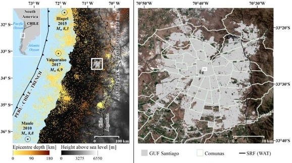
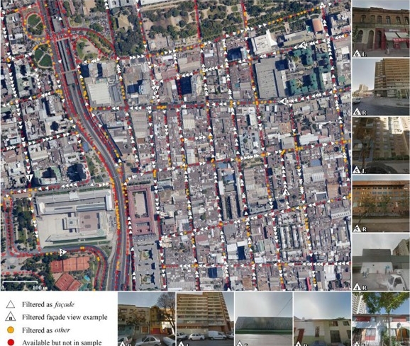
A new publication by Hannes Taubenböck and colleagues is online about “Automated building characterization for seismic risk assessment using street-level imagery and deep learning”. From the abstract: “Accurate seismic risk modeling requires knowledge of key structural characteristics of buildings. However, to date, the collection of such data is highly expensive in terms of labor, time and money and thus prohibitive for a spatially continuous large-area monitoring. This study quantitatively evaluates the potential of an automated and thus more efficient collection of vulnerability-related structural building characteristics based on Deep Convolutional Neural Networks (DCNNs) and street-level imagery such as provided by Google Street View. The proposed approach involves a tailored hierarchical categorization workflow to structure the highly heterogeneous street-level imagery in an application-oriented fashion. Thereupon, we use state-of-the-art DCNNs to explore the automated inference of Seismic Building Structural Types. These reflect the main-load bearing structure of a building, and thus its resistance to seismic forces. Additionally, we assess the independent retrieval of two key building structural parameters, i.e., the material of the lateral-load-resisting system and building height to investigate the applicability for a more generic structural characterization of buildings. Experimental results obtained for the earthquake-prone Chilean capital Santiago show accuracies beyond κ = 0.81 for all addressed classification tasks. This underlines the potential of the proposed methodology for an efficient in-situ data collection on large spatial scales with the purpose of risk assessments related to earthquakes, but also other natural hazards (e.g., tsunamis, or floods).”

read full article here:

P. Aravena Pelizari, C. Geiß, P. Aguirre, H. Santa María, Y. Merino Peña, and H. Taubenböck (2021) Automated building characterization for seismic risk assessment using street-level imagery and deep learning. ISPRS Journal of Photogrammetry and Remote Sensing

you may also like:

Press Release by University of Würzburg about our Arctic research

Press Release by University of Würzburg about our Arctic research

Our work in the Arctic on Svalbard was covered by the press team of the University of Würzburg. It covers our focus on studying the region’s ecosystems and the effects of climate change on its environment using Earth Observation methods. Please see the german version...

Prof Gustau Camps-Valls visits DLR-EOC

Prof Gustau Camps-Valls visits DLR-EOC

Today we had the great pleasure to welcome Prof Gustau Camps-Valls at DLR's Earth Observation Center (EOC).   Prof Gustau Camps-Valls is a Full Professor in Electrical Engineering and leads the Image and Signal Processing (ISP) group at Universitat de València (...

Advancing Forest Inventory: Field Trip to Sailershausen

Advancing Forest Inventory: Field Trip to Sailershausen

Today, staff from the Earth Observation Research Cluster conducted a field trip to Sailershausen to visit three fully inventoried forest plots and to discuss examples of remote sensing applications with the forestry administration of the University of Würzburg. The...

PhD defense by Alexandra Bell

PhD defense by Alexandra Bell

We cordially invite all EORC staff members, interested colleagues as well as students and the interested public to join the public defense by Alexandra Bell on her PhD "Spaceborne Remote Sensing for Policy - Supporting National Compliance with International Policy...

PhD defense by Jakob Schwalb-Willmann

PhD defense by Jakob Schwalb-Willmann

On March 31st at 2:00 PM, Jakob Schwalb-Willmann will defend his PhD thesis, "Potentials of Animal-Environment Interactions for Remote Sensing Research." The public defense will be held at John-Skilton Str. 4a, Lecture Room 1. All interested staff, students, and...