

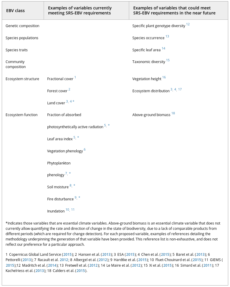
 Our article in the special issue on RS-EBVs is out on “framing the concept of remote sensing essential biodiversity variables”. From the abstract: Although satellite-based variables have for long been expected to be key components to a unified and global biodiversity monitoring strategy, a definitive and agreed list of these variables still remains elusive. The growth of interest in biodiversity variables observable from space has been partly underpinned by the development of the essential biodiversity variable (EBV) framework by the Group on Earth Observations – Biodiversity Observation Network, which itself was guided by the process of identifying essential climate variables. This contribution aims to advance the development of a global biodiversity monitoring strategy by updating the previously published definition of EBV, providing a definition of satellite remote sensing (SRS) EBVs and introducing a set of principles that are believed to be necessary if ecologists and space agencies are to agree on a list of EBVs that can be routinely monitored from space. Progress toward the identification of SRS-EBVs will require a clear understanding of what makes a biodiversity variable essential, as well as agreement on who the users of the SRS-EBVs are. Technological and algorithmic developments are rapidly expanding the set of opportunities for SRS in monitoring biodiversity, and so the list of SRS-EBVs is likely to evolve over time. This means that a clear and common platform for data providers, ecologists, environmental managers, policy makers and remote sensing experts to interact and share ideas needs to be identified to support long-term coordinated actions.

Mapping Lava Tubes on Mauritius with iPhone Pro LiDAR
Lava tube structures on Mauritius are quite hard to survey - tight, dark, and largely inaccessible to classical scanning equipment. As part of ongoing research by Dr. Kim Lea Holzmann (Chair of Animal Ecology and Tropical Biology, University of Würzburg), we're...


