Successful SIMWE Model Application for Flood Simulation in the realm of EO4CAM

Successful SIMWE Model Application for Flood Simulation in the realm of EO4CAM

May 14, 2025

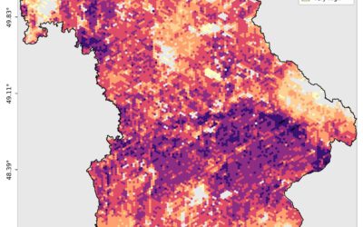
The SIMWE model (r.sim.water) was successfully presented at the municipal level in Markt Burgheim, showcasing its capabilities for local flood risk assessment. Key contributions were made by EORC colleagues Sofia Haag, Christian Schäfer and John Friesen from the EO4CAM project in conducting initial test simulations, including a heavy rain event from September 2, 2024, and a sensitivity analysis for accurate depression representation.

Subsequently, five additional heavy rain events were simulated. The results, including detailed maps and evaluations highlighting common floodplains, were presented to stakeholders. Discussions on the next steps focused on integrating these findings into the existing GIS infrastructure and exploring potential monitoring and protective measures.

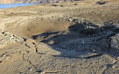
Following the presentation, the colleagues also undertook a brief field trip to investigate the catchment area, enhancing their ground-truth understanding.

you may also like:

Invited presentation at the MIND-Academy 2025

Invited presentation at the MIND-Academy 2025

The MIND Academy is an annual event, which takes place on the first weekend in October – this year in Mannheim. Over the four to five days, lectures from a wide range of scientific fields are organized under a specific overarching theme (this year it is...

Field Excursion to Owabi Wildlife Sanctuary

Field Excursion to Owabi Wildlife Sanctuary

As a highlight of the third day of our training at KNUST on the use of remote sensing for biodiversity conservation, we took our participants on a field excursion to the nearby Owabi Wildlife Sanctuary. Guided by experienced local experts, we explored the area and had...

Expedition to Central Asia in the frame of the FluBig project

Expedition to Central Asia in the frame of the FluBig project

Since mid of September, a team from the Earth Observation Research Cluster is on a field expedition at the Naryn River in Kyrgyzstan. The team is acquiring data on vegetation and hydro-geomorphic features for the DFG funded "FluBig" project which is dedicated to...

EOCap4Africa training in Kumasi

EOCap4Africa training in Kumasi

Today, we launched the testrun for our MSc module on Remote Sensing for Biodviversity Conservation which forms part of the EOCap4Africa project (funded by the Federal Agency of Nature Conservation) at the Kwame Nkrumah University of Science and Technology (KNUST) in...

Final workshop on research project OptiPlan

Final workshop on research project OptiPlan

Final workshop on research project OptiPlan (Ein innovatives KI-basiertes Planungstool zur Verkehrserfassung für nachhaltiges Flächenmanagement mittels Kamera- und Satellitenbilddaten)On September 19, 2025, the consortium of the OptiPlan project (German Aerospace...