MSc by Asja Bernd: “Mind the Gap: A Global Analysis of Grassland Fragmentation using MODIS Land Cover Data”

MSc by Asja Bernd: “Mind the Gap: A Global Analysis of Grassland Fragmentation using MODIS Land Cover Data”

April 15, 2015

AsjaBernd_MSc_GlobalChangeEcology_org_2015_resizedeast_africa_af_areaThe MSc thesis by Asja Bernd titled “Mind the Gap: A Global Analysis of Grassland Fragmentation using MODIS Land Cover Data” is handed in. Very interesting results on global grassland fragmentation. Read the abstract:

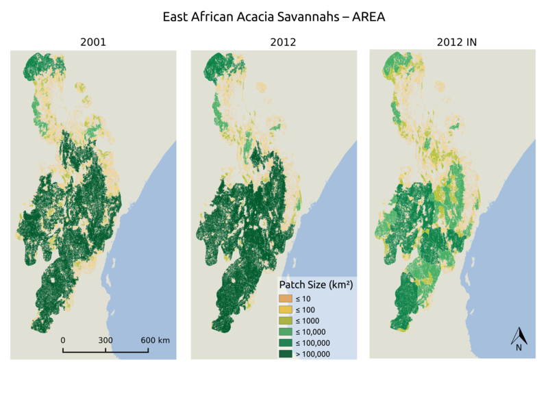
Around the world, grassland and savannah ecosystems are under intense anthropogenic use, yet research has not given them much attention. One significant threat is fragmentation, reducing habitat connectivity and hindering species dispersal. Using MODIS land cover data from 2012, combined with infrastructure data derived from VMAP0 and OpenStreetMap, I assessed the fragmentation of grasslands on a global scale. The metrics applied were patch size, distance to the euclidean nearest neighbour and number of neighbours per patch. To quantify the contribution of human pressure to fragmentation, the results were correlated with the Human Influence Index and human population density. For subsets, selected from the Global 200 Ecoregions, I analysed land cover data from 2001 and 2012 to determine
trends over time. Globally, grasslands are highly fragmented by infrastructure, which reduced patch size by more than 50 %, and significantly increased isolation. Human pressure seems to act as a driver of fragmentation, diminishing patch size and the number of neighbours, while increasing the distance to neighbours. For the subsets, results varied, but two of three metrics indicated an increase in fragmentation between 2001 and 2012. In the face of declining migrations of terrestrial mammals and increasing human pressure, a better understanding of the effects of fragmentation is needed to develop adequate management and protection strategies.

Supervisor: Prof. Neil Burgess and Dr. Martin Wegmann

follow us and share it on:

you may also like:

Drone manufacturer Wingtra visits EORC

Drone manufacturer Wingtra visits EORC

Is it possible to combine the efficiency of a fixed-wing drone with the precision of a laser scanner? That question brought researchers from EORC together with Wingtra, a Swiss company designing and manufacturing fixed-wing UAS, to exchange on UAS research and discuss...

How We Learned to Fly: The Story Behind UAS Research at EORC

How We Learned to Fly: The Story Behind UAS Research at EORC

Every research group that's ever bought a drone has a story about the first one it lost. We're no different. So let's just get that out of the way up front: this is the inside story of how UAS (Unoccupied Aerial System) research grew up at the Earth Observation...

MainPro workshop on TLS and LiDAR UAS

MainPro workshop on TLS and LiDAR UAS

This week, a workshop organized by Sebastian Buchelt within our EFRE project MainPro brought together students, researchers, and interested project partners to explore modern UAV technologies. The workshop took place in vineyards close to Würzburg and gave the...

25 Years of Remote Sensing in Würzburg

25 Years of Remote Sensing in Würzburg

Our chair of remote sensing, Professor Stefan Dech, likes to say "science is rarely a sprint, it's a marathon". And if you look at what's grown out of Würzburg over the last 25 years, you'll see exactly what he means. In 2026 the Julius-Maximilians-Universität...

Starkregen in Bayern: Beobachtungen und Dokumentation zählen

Starkregen in Bayern: Beobachtungen und Dokumentation zählen

Starkregenereignisse treten immer häufiger lokal, kurzfristig und mit hoher Intensität auf. Innerhalb weniger Stunden können sie erhebliche Überschwemmungen und Schäden verursachen. Um solche Ereignisse künftig besser zu verstehen und die wissenschaftliche Grundlage...

Seeing the World in Points: Lidar Course for the EAGLEs

Seeing the World in Points: Lidar Course for the EAGLEs

Lidar has a funny way of sneaking up on you. You think you know what it is, a laser that measures distance, fine, but then someone shows you a point cloud of a forest canopy with individual branches floating in 3D space and suddenly you realize there's a whole...

Share This