New Publication on Automated building characterization

New Publication on Automated building characterization

September 15, 2021

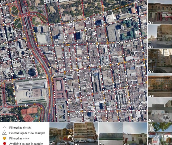
A new publication by Hannes Taubenböck and colleagues is online about “Automated building characterization for seismic risk assessment using street-level imagery and deep learning”. From the abstract: “Accurate seismic risk modeling requires knowledge of key structural characteristics of buildings. However, to date, the collection of such data is highly expensive in terms of labor, time and money and thus prohibitive for a spatially continuous large-area monitoring. This study quantitatively evaluates the potential of an automated and thus more efficient collection of vulnerability-related structural building characteristics based on Deep Convolutional Neural Networks (DCNNs) and street-level imagery such as provided by Google Street View. The proposed approach involves a tailored hierarchical categorization workflow to structure the highly heterogeneous street-level imagery in an application-oriented fashion. Thereupon, we use state-of-the-art DCNNs to explore the automated inference of Seismic Building Structural Types. These reflect the main-load bearing structure of a building, and thus its resistance to seismic forces. Additionally, we assess the independent retrieval of two key building structural parameters, i.e., the material of the lateral-load-resisting system and building height to investigate the applicability for a more generic structural characterization of buildings. Experimental results obtained for the earthquake-prone Chilean capital Santiago show accuracies beyond κ = 0.81 for all addressed classification tasks. This underlines the potential of the proposed methodology for an efficient in-situ data collection on large spatial scales with the purpose of risk assessments related to earthquakes, but also other natural hazards (e.g., tsunamis, or floods).”

read full article here:

P. Aravena Pelizari, C. Geiß, P. Aguirre, H. Santa María, Y. Merino Peña, and H. Taubenböck (2021) Automated building characterization for seismic risk assessment using street-level imagery and deep learning. ISPRS Journal of Photogrammetry and Remote Sensing

follow us and share it on:

you may also like:

When Snow Disappears Too Early

When Snow Disappears Too Early

Fieldwork during the winter season in Svalbard usually comes with a built-in advantage: snow. It acts as a natural transport layer, making it possible to move efficiently across large distances with snowmobiles and sleds. You plan your campaign around that mobility:...

Advancing Agriculture with UAS Multi-Sensor Research

Advancing Agriculture with UAS Multi-Sensor Research

Understanding how agriculture can adapt to a changing climate is one of the key challenges of our time. At EORC, we are pleased to share that our researchers are currently collaborating with the Bavarian State Research Center for Agriculture (LfL) on an innovative...

New roll-up shows Urban Collaboration and Research

New roll-up shows Urban Collaboration and Research

Remote sensing thrives on collaboration as shown (by a few selected ones) on our most recent roll-up. Many of today’s most pressing urban and environmental challenges—rapid urbanization, climate change, landcover change, migration, inequality, and economic...

Hackathon within the Super-Test-Site Project

Hackathon within the Super-Test-Site Project

What happens when researchers and developers sit down together to explore a multidisciplinary urban dataset? Our researchers from the EORC joined a hackathon that took place within the Super-Test-Site Project, organised by Prof. Dr. Gunther Gust from the Chair of...

Field Days in the Oberpfalz: Exploring FSME Hotspots

Field Days in the Oberpfalz: Exploring FSME Hotspots

On April 17th and 29th our researchers Sofía and Ariane had two field days in the areas around Amberg and Schwandorf, one of Germany's most well-known TBE (tick-borne encephalitis) risk regions. They joined Prof. Dr. Gerhard Dobler and Dr. Lidia Chitimia-Dobler from...

Share This