T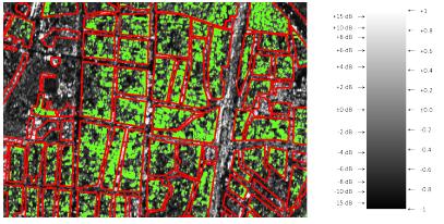 obias Sieg submitted his MSc thesis “The potential of interferometric and polarimetric SAR data to characterize urban areas at the example of Mumbai and Manila” successfully and started with his PhD soon after. The thesis has been conducted in close cooperation with the DLR-EOC (Schmidt, Taubenböck) within the Global Change Ecology MSc study program. A publication is aimed at and is planned to be submitted within the end of this year. The studies, conducted in the course of this thesis, prove the feasibility of interferometric and polarimetric SAR data to separate between urban areas with different apparent structures. Further studies should aim for investigating an improvement of this separation and its reliability e.g. by means of polarimetric SAR data with an even higher spatial resolution or the use of enhanced TanDEM-X datasets. However, the use of SAR products with a spatial resolution lower than 2 meters is very limited. Furthermore, this thesis proves the suitability of the framework of the Kennaugh elements and the Schmittlet coefficients to characterize and separate urban areas. Especially the use of the Schmittlet coefficients to assess structures of cities in the future is highly recommended. Also, the use of nDSM data in conjunction with the Schmittlet coefficients is proved to increase the separability between building areas with different building heights tremendously. Once these results are further approved by the application of better suited datasets and the conduction of the methods to a few more cities, they could potentially serve as an helpful source of information for many other studies dealing with urban environments. For example, the results of the area-wide separability of chapter 4 could serve as an pre-classification to detect informal settlements, which could be helpful for urban planners. Also with regard to urban climate, information about the height and the structure or density can help to improve urban climate models. The estimation of the number of inhabitants of a city could benefit from a reliable pre-classification.

Learning Geospatial Tools in Practice: whitebox
A central goal of the EAGLE Earth Observation programme is to equip students with a broad and practical understanding of the software tools used in geospatial analysis. Rather than focusing on a single platform, students are encouraged to explore different approaches,...