
Exposure data is essential for effective disaster management. Remote sensing is of great importance for generating large-scale and up-to-date exposure information. However, the accuracy of the derived exposure information varies. But how accurate does it need to be to be of practical use? A recently published study examines precisely this question.
This new publication entitled ‘How accurate is accurate enough? Assessing the influence of exposure data quality on tsunami damage modelling using the 2011 Tōhoku tsunami’ investigates the sensitivity of tsunami-induced building damage modelling with respect to exposure data accuracy using the 2011 Tōhoku tsunami. The paper has just been published in the Journal ‘Progress in Disaster Science’ by Christian Geiß, Miyo-Maria Haug, Marc Wieland, Bruno Adriano, Patrick Aravena Pelizari, Hannes Taubenböck and Shunichi Koshimura. The team of authors is from the Earth Observation Center (EOC) of the German Aerospace Center (DLR), the University of Bonn, the Tohoku University in Japan and our Earth Observation Research Cluster (EORC) of the University of Würzburg.
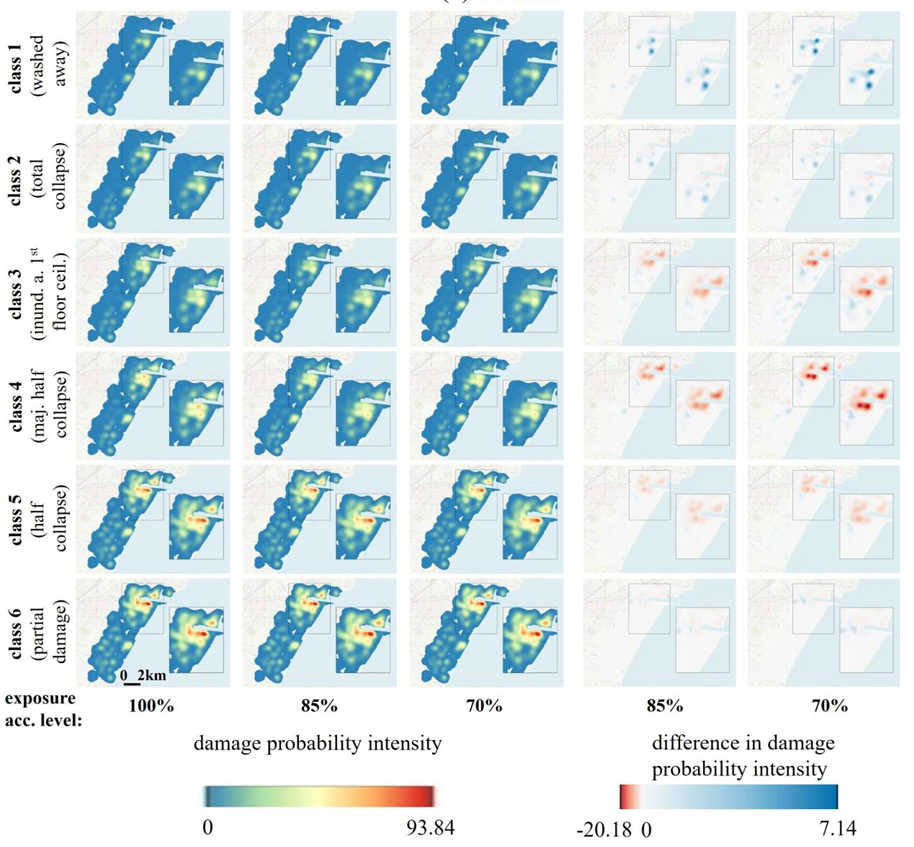
Here is the abstract of the paper Accurate exposure data are widely regarded as a prerequisite for reliable disaster damage modelling, yet empirical evidence on how accurate exposure data actually need to be remains limited. This study investigates the sensitivity of tsunami-induced building damage modelling with respect to exposure data accuracy using the 2011 Tōhoku tsunami as a large-scale empirical case study. Focusing on three urban contexts in Miyagi prefecture, i.e., Kesennuma, Ishinomaki, and Sendai, we systematically degrade exposure data, i.e., building-type accuracy, in a high-quality post-event dataset and analyze the resulting changes in predicted damage patterns. Univariate tsunami fragility functions based on inundation depth are computed to estimate building damage probabilities, which are subsequently aggregated into spatial damage probability surfaces. Model performance is evaluated by using mean absolute error, root mean square error, and structural similarity index metrics. Results reveal a non-linear sensitivity of model performance to exposure data accuracy, with the largest marginal losses concentrated at the high-accuracy end of the scale. At the same time, the univariate framework retains substantive predictive capability even under substantially reduced accuracy conditions, consistently outperforming randomized baselines. Thus, this study provides empirical guidance for balancing exposure data acquisition effort and model performance in disaster risk assessment procedures.
The open access paper can be read or downloaded here: https://www.sciencedirect.com/science/article/pii/S2590061726002516?via%3Dihub
For more related works on exposure, vulnerability and risk assessment, please see some selected studies here:
- Bottom-up exposure modeling with multimodal earth vision. https://www.sciencedirect.com/science/article/pii/S0924271625004241
- Benefits of Global Earth Observation Missions for Exposure Estimation and Earthquake Loss Modelling – Evidence from Santiago de Chile, Chile. https://link.springer.com/article/10.1007/s11069-022-05672-6
- Multitemporal Landslide Exposure and Vulnerability Assessment in Medellín, Colombia. https://link.springer.com/article/10.1007/s11069-022-05679-z
- Automated building characterization for seismic risk assessment using street-level imagery and deep learning. https://www.sciencedirect.com/science/article/pii/S0924271621001817
- Joint Use of Remote Sensing Data and Volunteered Geographic Information for Exposure Estimation: Evidence from Valparaíso, Chile. https://link.springer.com/article/10.1007/s11069-016-2663-8
- Estimation of seismic vulnerability levels of urban structures by joint exploitation of in-situ data and multi-sensor remote sensing. https://ieeexplore.ieee.org/document/7150321
- Estimation of seismic building structural types using multi-sensor remote sensing and machine learning techniques. https://www.sciencedirect.com/science/article/pii/S0924271614002007
- Assessment of buildings‘ seismic vulnerability from space. https://onlinelibrary.wiley.com/doi/10.1193/121812EQS350M
- Assessing building vulnerability to earthquake and tsunami hazard using remotely sensed data. https://link.springer.com/article/10.1007/s11069-012-0481-1
- A conceptual vulnerability and risk framework as outline to identify capabilities of remote sensing. https://nhess.copernicus.org/articles/8/409/2008/