
As part of our recent WASCAL-DE-Coop project, our colleagues from the Department of Physical Geography, namely Boris Ouattara, Barbara Sponholz and Heiko Paeth, published together with us and partners from Canberra (Australia), Montpellier (France), WASCAL in Ouagadougou (Burkina Faso) and Sunyani (Ghana) a new paper on “Enhancing burned area monitoring with VIIRS dataset: A case study in Sub-Sahara Africa“.
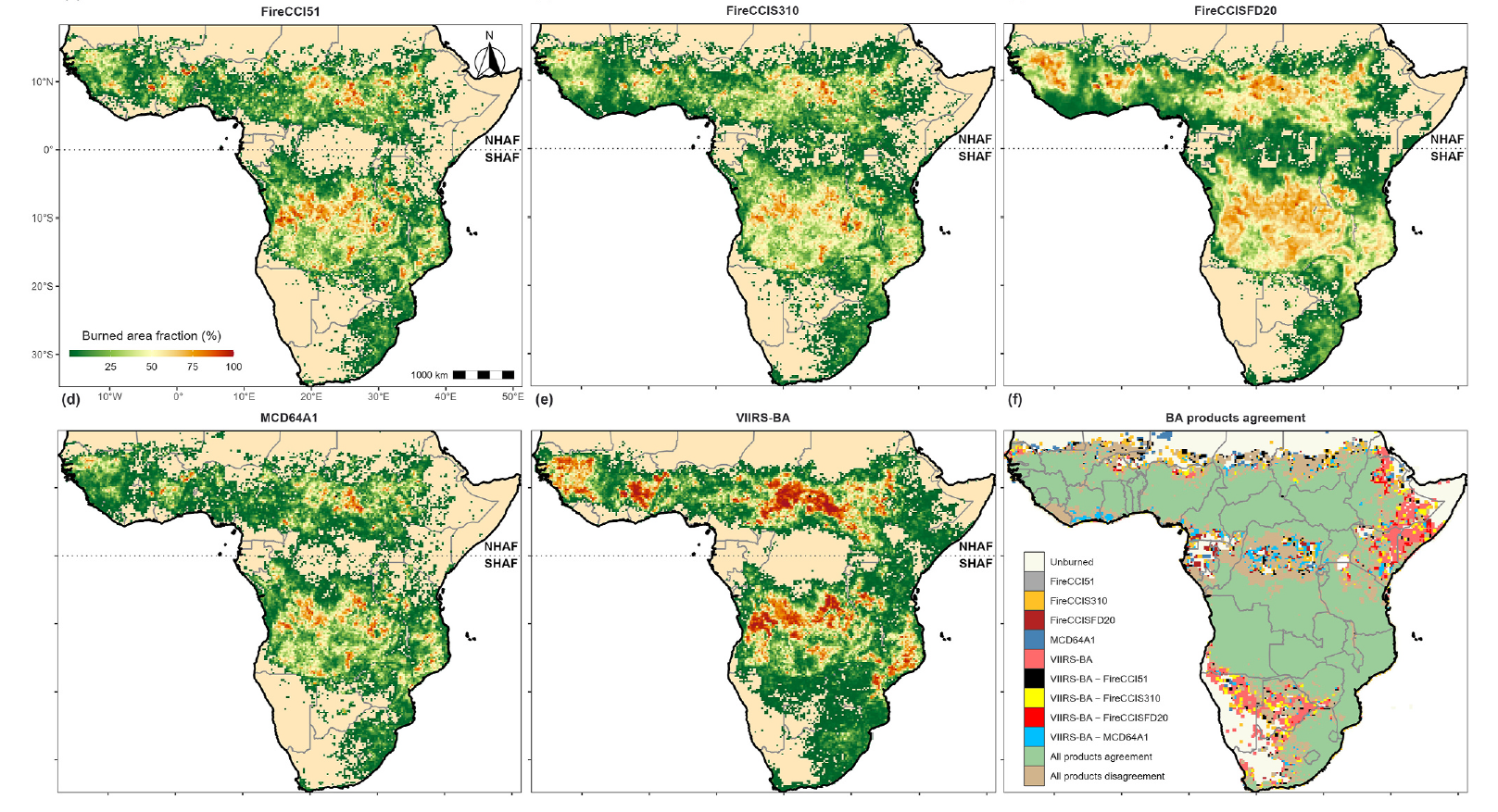
The abstract: Since 2001, the Moderate Resolution Imaging Spectroradiometer (MODIS) sensor on board the Aqua and Terra platforms has made great strides in providing information on global burned areas (BA). However, the MODIS mission is nearing its end. The Visible Infrared Imaging Radiometer Suite (VIIRS) sensors, presented as the MODIS Aqua heritage, could be an excellent alternative to ensure the temporal continuity of this information at a moderate resolution. This paper describes and evaluates the effectiveness of our developed hybrid algorithm, which utilizes VIIRS reflectance and active fire products on the Google Earth Engine platform, in producing efficient information about BA. The study investigates the algorithm’s performance in sub-Saharan Africa as the region of interest in 2019, using biweekly outputs and a spatial resolution of 250 m. The algorithm encompasses several steps, including pre-processing individual scenes, creating cloud-free composites, generating binary reference data for burned and non-burned areas, conducting a supervised classification using random forest, and performing region shaping. The VIIRS-BA final product, which includes three confidence levels (low, moderate, and high) known as the uncertainty layer, is compared to four other burned area products. The validation is conducted against 27 reference sampling units from the Sentinel-2 Burned Area Reference Database dataset, allowing for a comprehensive uncertainty assessment across five various biomes. The VIIRS-BA product identified 5.1 million km2 of BA, which was significantly larger than other global coarse resolution BA products such as FireCCI51, FireCCIS310, and MCD64A1 and close to the fine resolution FireCCISFD20 with a difference of 7.3%. The differences were less significant in biomes such as “Tropical Savannas” and “Temperate Grasslands” which are characterized by persistent biomass burning. Based on a stratified random sampling, the validation results demonstrate varying levels of accuracy for the VIIRS-BA product across different confidence levels. The commission error (CE) ranges from 7.8% to 23.4%, while the omission error (OE) falls between 29.4% and 58.8%. Notably, there is a significant reduction in OE (ranging from 40.7% to 50.5%) compared to global BA products like FireCCI51, FireCCIS310, and MCD64A1. When compared to VIIRS-BA, the FireCCISFD20 regional product has a 37% better OE performance. While VIIRS-BA shows great potential in detecting fires that global products miss, the VIIRS-BA with low confidence level tends to overestimate BA in regions with high fire activity. To address this, future versions of the algorithm will integrate the updated VIIRS reflectance data alongside VIIRS
active fire from the National Oceanic and Atmospheric Administration to reduce CE and improve understanding spatial patterns.
Link to the article: https://www.sciencedirect.com/science/article/pii/S266601722400049X