Short UAV field training with our guest Olanike Deji

Short UAV field training with our guest Olanike Deji

July 19, 2023

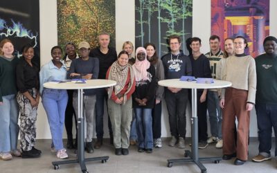
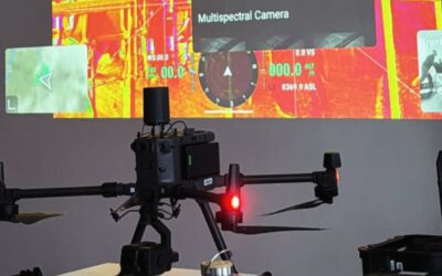
Today we went out for a short field training session with our guest scientist Prof. Dr. Olanike Deji (Obafemi Awolowo University, Ile-Ife, Nigeria) who’s research stay is funded by the Alexander von Humboldt Foundation. Supported by our EAGLE students Ronja Seitz and Sunniva McKeever we collected some example images of maize fields in the rural areas around Würzburg. We see this training as a first step into future cooperation in the monitoring of agricultural areas in Nigeria.

follow us and share it on:

you may also like:

EORC researchers teaching drone remote sensing at UNIS, Svalbard

EORC researchers teaching drone remote sensing at UNIS, Svalbard

During their current visit to Svalbard, EORC researchers have been teaching UNIS students from all over Europe on how drones can be used for remote sensing in the high Arctic. Invited by our UNIS collaborators Prof. Dr. Simone Lang (UNIS) and Prof. Dr. Eero Rinne...

Urban Earth Observation Lecture: Understanding Cities from Above

Urban Earth Observation Lecture: Understanding Cities from Above

As part of the EAGLE M.Sc. programme, our international students attended this winter term the Urban Earth Observation lecture by EORC professor Hannes Taubenböck. The session offered a comprehensive overview of how remote sensing has evolved into a central tool for...

EAGLE Internship Presentation EO on Svalbard

EAGLE Internship Presentation EO on Svalbard

On February 24, 2026, Leonie Sonntag and Jannis Midasch will present their internship results on " Earth Observation Application on Svalbard" at 13:00 in seminar room 3, John-Skilton-Str. 4a. During March and April 2025, EAGLE MSc students Leonie Sonntag and Jannis...

Learning Geospatial Tools in Practice: whitebox

Learning Geospatial Tools in Practice: whitebox

A central goal of the EAGLE Earth Observation programme is to equip students with a broad and practical understanding of the software tools used in geospatial analysis. Rather than focusing on a single platform, students are encouraged to explore different approaches,...

Share This