


When animals roam the savanna, e.g. to find resources, they leave distinctive paths in the landscape. The resulting path networks show how animals differentiate and interact with their environment. Information on the animals’ space use at great spatial detail is important to understand their selection behavior. However, conventional methods for deriving animal paths such as tracking techniques often produce spatio-temporally sparse data at an accuracy above meters. High-resolution remote sensing from Unoccupied Aerial Systems (UAS, or drones) on the other hand delivers imagery at spatial resolutions of a few centimeters, allowing to differentiate animal paths from their surroundings even when paths are narrow and hard to spot.
Manual annotation of such paths in image data is slow and expensive. Thus, the EORC has been working on the automated segmentation of animal paths in UAS imagery (see for example our recently published peer-reviewed paper in collaboration with our partner SanParks in South Africa). However, paths are thin, low-contrast, and interrupted by vegetation. Their automatic detection remains challenging.
In continuation of these efforts, informatics master’s student Iryna Musiienko has been working on enhancing our deep learning techniques to detect animal paths in UAS imagery. Building on the foundation of Konstantin Müller’s master thesis work for which he had developed and compared neural networks for animal path segmentation, Iryna investigated how to enhance the method and improve results. As part of the project, she successfully reproduced our original results on our University’s computation cluster. She then introduced and tested new metrics to better quantify path segmentation accuracy compared to area-based metrics used previously, including Average Symmetric Centreline Distance (ASCD), Centreline Recall and Centreline-Precision. Since manual model tuning for finding working configurations, Iryna applied nnUNet (“no-new-Net”), a self-configuring method for deep learning-based image segmentation, orginally used for biomedical data. nnUNet extracts dataset properties into a “fingerprint”, selects the optimal models ensemble and determines postprocessing necessity, and infers data-dependent rule-based parameters to determine fixed parameters for optimal results. Iryna could show that the use of nnUNet over manually-tuned networks increased performance, successfully concluding her student project.
The student project was supervised by Prof Dr. Katharina Breininger (Informatics/CAIDAS, University of Würzburg), Konstantin Müller (EORC) and Dr. Jakob Schwalb-Willmann (EORC) as part of research initiated by Dr. Mirjana Bevanda and colleagues from SANParks at Kruger National Park, including Dr. Benjamin Wigley and Dr. Corli Coetsee.
The collaboration between EORC and the Pattern Recognition group at the Centre for Artificial Intelligence and Data Science (CAIDAS) lead by Prof. Dr. Katharina Breininger opens new possibilities and synergies in Earth observation and Deep learning across teams and disciplinary boundaries.
It is exciting for us to see an outcome of combining scientific expertise in pattern recognition in (biomedical) imagery, and remote sensing and geo-spatial analysis for ecological research!
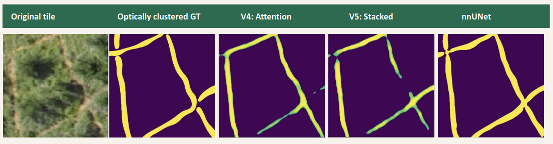
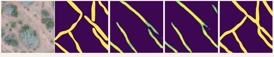
Examples of predictor image, ground truth, and three different predictions, including one by nnUNet.


