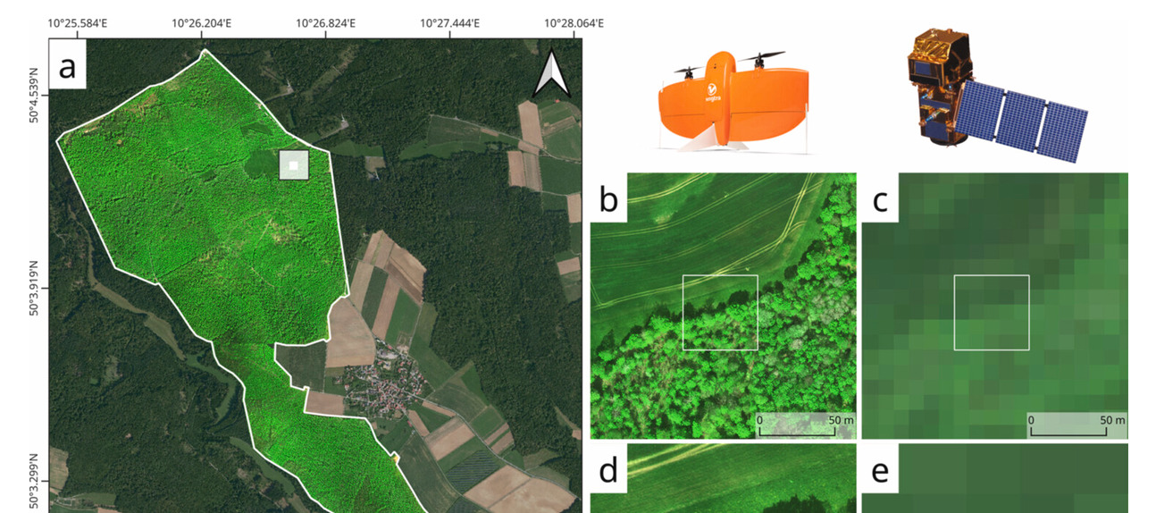

A new paper in GIScience & Remote Sensing “Multi-temporal analysis of reflectance and vegetation index consistency between Sentinel-2 and UAS imagery over a managed broadleaved forest: implications for monitoring”, with several EORC researchers among the authors, puts that to the test. The analysis led by Antonio José Castañeda-Gómez, with Mirjana Bevanda, Jakob Schwalb-Willmann, Tobias Ullmann, and colleagues, flew a fixed-wing UAS with a MicaSense Altum multispectral sensor over a 300 ha managed broadleaved forest. They repeated the flights about every two weeks for six months, timed to Sentinel-2 overpasses – and compared both data acquisitions.
The drone data turned out noisier at native resolution, especially in the red-edge band. That’s no surprise given how much fine-scale light and canopy structure it picks up. Aggregating it to Sentinel-2 pixels helped, but didn’t fix everything. The best agreement showed up in the green, red and near-infrared bands. Among the indices, NDVI and GNDVI held up best, both across the whole time series and on single dates. Simple ratio indices and anything built on red-edge bands drifted more.
So for combining the two platforms, stick to normalized difference indices from well-matched bands. The drone can then fill gaps in the satellite series and link canopy detail to the bigger picture.
the abtract:
The comparability between satellite-based and uncrewed aerial system (UAS) imagery is critical for multiscale forest monitoring. It enables the integration of fine-resolution observations into a broader satellite-derived spatial and temporal context. Understanding this comparability supports the strategic use of centimeter-resolution UAS data to address fine-scale ecological questions, to serve as gap-filling observations within satellite-based time series during periods of absent data retrievals, and to link fine-scale canopy structural variation to landscape-level vegetation dynamics observed from space. This study investigated the spectral and vegetation index level consistency between Sentinel-2 and UAS multispectral measurements acquired over a 300 ha managed broadleaved forest in Central Europe. UAS data were collected using a fixed-wing platform equipped with a MicaSense Altum multispectral sensor and temporally matched to Sentinel-2 overpasses over a 6-month period at approximately two-week intervals. Cross-platform agreement was quantified using distribution-based similarity metrics, spatial aggregation of UAS data to Sentinel-2 spatial resolution, intrinsic correlation analysis, and single-date regression modeling. At their native spatial resolutions, UAS observations exhibited systematically higher radiometric variability and stronger distributional asymmetry than Sentinel-2 data, particularly in the red-edge band, consistent with increased sensitivity to fine-scale illumination differences and canopy structural heterogeneity, and partly reflecting radiometric differences between individual UAS flights. Spatial aggregation of UAS data reduced this variability but did not fully remove wavelength-dependent discrepancies, with the highest levels of agreement consistently observed in the green, red, and near-infrared bands. Among the vegetation indices, normalized difference metrics, particularly the Normalized Difference Vegetation Index (NDVI) and the Green Normalized Difference Vegetation Index (GNDVI), showed the strongest and most temporally stable cross-platform consistency across both multitemporal distributions and individual acquisition dates. In contrast, simple ratio-based indices and indices incorporating red-edge wavelengths exhibited systematic distributional shifts and reduced temporal robustness. These distributional shifts are consistent with persistent sensor-level spectral response differences rather than index-specific artifacts. Collectively, these findings indicate that normalized difference indices built from spectrally well-matched bands, which largely remove radiometric differences between UAS flights, provide a robust basis for the joint exploitation of UAS and Sentinel-2 observations, enabling consistent multiscale monitoring of broadleaved forests while retaining the complementary advantages of each observational platform.
Read the paper: https://www.tandfonline.com/doi/full/10.1080/15481603.2026.2751249