course on Theory and Practice of UAS Operation and Methods

course on Theory and Practice of UAS Operation and Methods

March 13, 2025

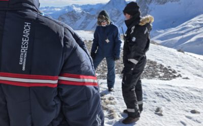
Last week our staff members Antonio Gomez Castaneda and Luisa Pflumm did an UAS course within out EAGLE M.Sc. program.

The primary objective of this course is to prepare students — from having no prior experience — to safely operate drones for scientific applications. Throughout the program, participants gain essential knowledge required to plan meaningful data collection missions, including:

  • Understanding different types of UAS platforms and their applications
  • Exploring various sensor technologies (multispectral, thermal, LiDAR)
  • Learning structure from motion (SfM) techniques
  • Mastering mission planning tools and workflows
  • Navigating airspace regulations and ensuring safe drone operations

Upon completing the intensive Theory and Practice of UAS Operation and Methods course, all students had the unique opportunity to fly state-of-the-art aircraft and apply their remote sensing knowledge to process and analyze newly collected data.

As a highlight of the winter course, students showcased their final projects, which focused on cutting-edge remote sensing applications, such as:

  • Assessment of Vegetation Health using Multispectral and Thermal Imagery from UAS
  • Vegetation Structure Mapping using UAV-generated LiDAR Point Clouds
  • Vegetation Structure Analysis with UAS-Based LiDAR

We were also thrilled to host three guest speakers:

  • Elio Rauth shared his experience flying UAS in extreme cold regions, including Zugspitze and Svalbard.
  • Marlene Bauer and Anna Bischof presented their internship work, detailing their UAS flights in the Kruger National Park and their ongoing Innovation Lab projects using drones for mangrove monitoring.

And a fun fact: despite mastering complex drone operations and high-tech sensors, it seems the most challenging task was folding the landing mat!

We are proud of the students’ dedication and enthusiasm, and we look forward to seeing their future contributions to the field of remote sensing and UAS technology!

you may also like:

PhD Defense by Dorothee Stiller

PhD Defense by Dorothee Stiller

Dorothee Stiller will defend her PhD thesis "Potential of Remote Sensing Data and Methods for Urban Transport Research" on 15th of September at 4 p.m. at the John-Skilton Straße 4a, seminar Room 2/00.B.03. Everyone who is interested is cordially invited to join her...

Strengthening Collaboration with SANParks for Conservation Research

Strengthening Collaboration with SANParks for Conservation Research

Our long-standing collaboration with Dr. Corli Coetsee and Dr. Ben Wigley from SANParks is moving forward with promising new research activities. The joint work is focusing on mapping savanna features more accurately such as trees, paths, or animals through innovative...

Exploring Future Collaborations on Fire Research in African Savannas

Exploring Future Collaborations on Fire Research in African Savannas

During recent discussions, new opportunities for collaboration emerged between Navashni Govender, Senior Conservation Manager at SANParks in Kruger National Park, Prof. Katharina Breininger, head of the Pattern Recognition Lab in Informatics, and Dr. Mirjana Bevanda...

Understanding Urban Heat in Germany

Understanding Urban Heat in Germany

In a world where summers grow ever hotter, understanding and combating urban heat islands is becoming more urgent than ever. A recent study by our Prof. Hannes Taubenboeck sheds new light on this challenge—and at its helm is Dr. Tobias Leichtle, Dr. Thilo Erbertseder...

Exploring Drought and Fire Impacts on African Savanna Vegetation

Exploring Drought and Fire Impacts on African Savanna Vegetation

In the past weeks, our research team has been preparing for a unique field experiment investigating how drought and fire influence African savanna vegetation. The work is part of the PhD by Luisa Pflumm, she is supported by our PhD student Antonio Castaneda and his...

Privacy Policy

Lehrstuhl für Fernerkundung & Lehrstuhl für Urbane Fernerkundung

Erdbeobachtung an der Universität Würzburg